Pica de Peñamellera
| Pica de Peñamellera | ||
|---|---|---|
|
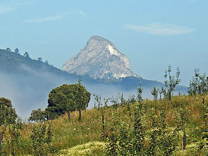
Pica de Peñamellera from the east |
||
| height | 765 msnm | |
| location | Asturias , Spain | |
| Mountains | Sierra Peñamellera, Cantabrian Mountains | |
| Notch height | 334 m | |
| Coordinates | 43 ° 19 '22 " N , 4 ° 39' 37" W | |
|
|
||
| First ascent | July 10, 1890 by Aymar de Saint-Saud | |
| Normal way | from the south, finally over the east ridge (I to II) | |
The Pica de Peñamellera (765 m, according to other sources 785 m) is a striking mountain on the lower reaches of the Río Cares in the northern Spanish autonomous region of Asturias . It is located on the border of the communities of Peñamellera Baja and Peñamellera Alta , for which it was named, and the mountain silhouettes depicted on the coats of arms of these communities are inspired by this mountain. The Pica de Peñamellera belongs to the Cantabrian Mountains and is located north of the Picos de Europa and directly south of the Sierra de Cuera , a mountain range about six kilometers from the sea.
Seen from the east, the shape of the mountain is reminiscent of the Matterhorn as seen from Zermatt , which is why the mountain is also called Cervino de Asturias .
The first documented ascent took place on July 10, 1890 by the French mountaineer and cartographer Aymar de Saint-Saud .
Individual evidence
- ↑ Pica Peñamellera at montesdeasturias.com
- ↑ a b c Peñamellera, Pica de at mendikat.net
- ↑ A la sombra de la Pica Peñamellera at elcomercio.es

