Pieczek
| Pieczek | ||
|---|---|---|
| height | 181.6 m npm | |
| location | Pomeranian Voivodeship , Poland | |
| Mountains | Baltic ridge | |
| Coordinates | 54 ° 19 '46 " N , 17 ° 34' 12" E | |
|
|
||
The Pieczek (German Pietschker Berg ) is a 181 meter high hill in the Polish Pomeranian Voivodeship .
Geographical location
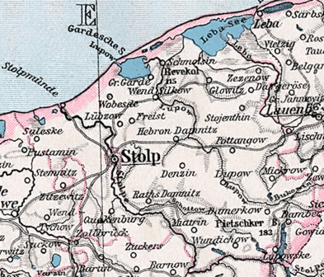
The Pieczek is located in Western Pomerania , southeast of Słupsk (Stolp) and west of Jezioro Jasień (Jessener See) and west of the village of Jerzkowice (Jerskewitz) . Southwest of the hill is the village of Unichowo (Wundichow) .
The Pieczek (Pietschker Berg) is 181.60 meters high before the Rowokół (Revekol) elevation with 115 meters, the largest elevation in the area of the former Stolp district .
literature
- Karl-Heinz Pagel : The district of Stolp in Pomerania . Lübeck 1989, pp. 583–586 ( Download location description Jerskewitz ) (PDF; 754 kB)
- Atlas of Prehistory (published by the Hamburg Museum for Folklore and Prehistory). Supplement, issue 8–11, Hamburg 1959.

