Pieninenweg
| Pieninenweg | |
|---|---|
 At the Dunajec |
|
| Data | |
| length | ~ 12 km |
| location | Middle Pieninese , Poland , Slovakia |
| Markers | White-red-white |
| Starting point |
Szczawnica 49 ° 25 '14.4 " N , 20 ° 27' 36.5" E |
| Target point |
Červený Kláštor 49 ° 23 ′ 57.7 ″ N , 20 ° 25 ′ 0.1 ″ E |
| Type | Path by the river |
| The highest point | 520 m |
| Level of difficulty | light |
| season | all year round |
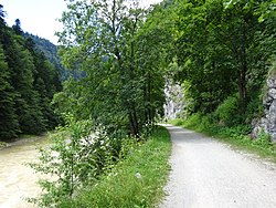
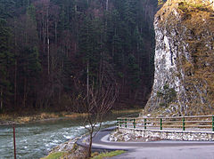
The Pieninenweg ( Polish Droga Pienińska ) is an approx. 12 km long hiking trail in the breakthrough of the Dunajec River in the Middle Pienines in Poland and Slovakia . It is easy to walk or ride a bike. It is closed to car traffic. The path was laid out by the Cracow Academy of Scholarship as early as the 1870s . In particular, Józef Szalay made a name for himself in the way from 1870 to 1875.
Location and route
The red marked path begins in the Polish spa town of Szczawnica not far from the Nowy Przewóz pier and the Orlica hut and ends at the Slovak monastery of Červený Kláštor . In Červený Kláštor you can return to the Polish side via the bridge i Sromowce Niżne and return to the Nowy Przewóz pier via the blue ridge path. You should plan a whole day for the circular route. For the Pieninenweg about three hours or one hour by bike. Bicycles can be rented in several places on Dunajec. There is also the possibility of renting a kayak in Sromowce, which the provider in Szczawnica exchanges for a bike that is returned in Sromowce.
gallery
See also
literature
- Witold Henryk Paryski, Zofia Radwańska-Paryska: Wielka encyklopedia tatrzańska. Wydawnictwo Górskie, Poronin 2004, ISBN 83-7104-009-1 .
- Józef Nyka: Pieniny. Przewodnik. 9th edition. Trawers, Latchorzew 2006, ISBN 83-915859-4-8 .
- Pieniny polskie i słowackie. Mapa turystyczna 1:25 000. Agencja Wydawnicza "WiT" sc, Piwniczna 2008, ISBN 978-83-907671-3-0 .


