
Pierre couverte (Beaupreau)

The Dolmen Pierre couverte of Beaupreau (also called L'Etang-Dolmen or Dolmen de Charcé) is located in a field, northwest of Charcé-Saint-Ellier-sur-Aubance in the Maine-et-Loire department in France . The menhir "Pierre levée de Beaupreau" stands nearby . In France, dolmen is the generic term for megalithic structures of all kinds (see: French nomenclature ). Dolmen of the same name are located near Parigné-le-Pôlin in the Sarthe department and in Pontigné in the Maine-et-Loire department.
description
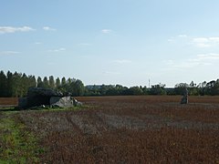
The Dolmen of Beaupréau is a large Angevin dolmen with a rectangular chamber about 4.0 × 3.0 meters. The only capstone lying in situ lies on the two large side stones and the end stone. The west-east oriented dolmen opens to the east and there are the usual stone pairs of the entrance portal, of which the northern one has fallen over.
On the west side are the remains of a smaller (end) chamber, which is separated from the main chamber by the end stone and collapsed. The large partition plate has bowls and 40 grooves .
The dolmen has been classified as a monument historique since 1889 .
About 30 meters west of the dolmen is the Pierre levée de Beaupreau, a pointed menhir about 3.0 m high .
- Pierre couverte by Beaupreau


Distribution map of dolmen in Maine-et-Loire - preserved structures are green


See also
literature
- Michel Gruet: Mégalithes en Anjou 2005 (1re éd. 1967, actualization de Charles-Tanguy Le Roux). ( ISBN 284478397X ), pp. 59-61
Remarks
- ↑ The dolmen angevin is an allée couverte of the Loire type with a (retracted) trilith portal as an entrance, like the dolmen de la Pierre Folle in Bournand.
Web links
- Pierre couverte von Beaupreau in the Base Mérimée of the French Ministry of Culture (French)
- Description Engl. and pictures
Coordinates: 47 ° 21 ′ 39.8 ″ N , 0 ° 25 ′ 5 ″ W.