Piketone
| Piketone | |
|---|---|
 |
|
| Location in Ohio | |
| Basic data | |
| State : | United States |
| State : | Ohio |
| County : | Pike County |
| Coordinates : | 39 ° 4 ′ N , 83 ° 1 ′ W |
| Time zone : | Eastern ( UTC − 5 / −4 ) |
| Residents : | 2,181 (as of: 2000) |
| Population density : | 335.5 inhabitants per km 2 |
| Area : | 6.6 km 2 (about 3 mi 2 ) of which 6.5 km 2 (about 3 mi 2 ) is land |
| Height : | 175 m |
| Postal code : | 45661 |
| Area code : | +1 740 |
| FIPS : | 39-62708 |
| GNIS ID : | 1061541 |
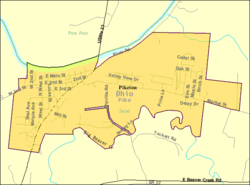
Piketon is a village ( Village ) of Pike County in the US state of Ohio with over 2,000 inhabitants.
The place on the Scioto River was from 1815 to 1845 the administrative seat of the county.
During the tornado outbreak from 2/3 In March 2012 , just southwest of Piketon, at the Portsmouth Gaseous Diffusion Plant uranium enrichment facility, only a few trees and a mobile home were damaged, as this was only a tornado of the weakest level EF0, while the stronger level EF4 raged over Kentucky 100 kilometers away .
Personalities
- Robert Lucas (1781-1853), governor
Web links
Commons : Piketon, Ohio - Collection of pictures, videos, and audio files
Individual evidence
- ^ Piketon in the United States Geological Survey's Geographic Names Information System , accessed April 9, 2014
