Pinos (Zacatecas)
| Pinos | ||
|---|---|---|
|
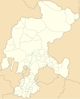
Coordinates: 22 ° 18 ′ N , 101 ° 35 ′ W Pinos on the map of Zacatecas
|
||
| Basic data | ||
| Country | Mexico | |
| State | Zacatecas | |
| Municipio | Pinos | |
| City foundation | 1594 | |
| Residents | 5611 (2010) | |
| Detailed data | ||
| surface | 2.54 km 2 | |
| Population density | 2,209 inhabitants / km 2 | |
| height | 2475 m | |
| Pinos - Church of San Matías | ||
Pinos is a place with about 6,500 inhabitants and the capital of a municipality ( municipio ) consisting of several villages and haciendas of about 80,000 inhabitants in the Mexican state of Zacatecas . The historic core of the town belongs since 2010 to UNESCO - World Heritage Sites of Camino Real de Tierra Adentro . In 2012, Pinos was added to the list of Pueblos Mágicos .
Location and climate
The city of Pinos is located in the southeast of the state of Zacatecas about 500 km (driving distance) northwest of Mexico City at an average altitude of about 2475 m ; the city of Zacatecas is about 140 km to the north-west. The climate is warm; Rain (approx. 480 mm / year) falls predominantly in the summer half-year.
Population development
| year | 2000 | 2005 | 2010 |
| Residents | 4,597 | 5.106 | 5,611 |
The slight but steady increase in population is mainly due to the ongoing immigration of families from the surrounding villages.
economy
Ores were mined in the vicinity of the village until the 19th century; other settlers founded large haciendas . Livestock raising (cattle, sheep, goats, pigs) plays the most important role in the life of the community; In addition, the cultivation of grain (maize, wheat, barley) and the cultivation of fruit and vegetables (beans, chillies, tomatoes, prickly pears, peaches, pears, figs, etc.) are important. Small traders, craftsmen and service providers of all kinds have settled in the city itself.
history
Before the arrival of the Spaniards, the area belonged to the settlement area of the warlike tribe of the Guachichils , a subgroup of the Chichimecs . The place founded in 1594 under the name Real de Nuestra Señora de la Purísima Concepción de Cuzco y Descubrimiento de Minas que llaman de la Sierra de Pinos was near the "Silver Road" (Camino Real de Tierra Adentro) , which crossed from Mexico City Guanajuato to Zacatecas and further north ran. It is interesting to note that the Tlaxcalteks, allied with the Spaniards, were assigned their own settlement area here. It was not until 1824 that Pinos received city rights.
Attractions
- The most important buildings in the city are in the main square (Plaza de Armas) .
- The Church of San Matías was started at the end of the 17th century, but the entire complex was never completed. The late baroque facade in the style of Churriguerism is one of the main attractions of the city.
- The convent and two-tower church of San Francisco are on the north side of the square. The church houses an image of Nuestro Padre Jesús , who is highly venerated in the region.

