Pit River Bridge
Coordinates: 40 ° 45 ′ 44 ″ N , 122 ° 19 ′ 8 ″ W.
| Pit River Bridge | ||
|---|---|---|
|
The Pit River Bridge over Shasta Lake 2016, view to the northeast of the branch of the McCloud River (filling of the reservoir was approx. 80% of the average) |
||
| Official name | Veterans of Foreign Wars Memorial Bridge | |
| use |
rail bridge |
|
| Crossing of |
Pit River ( Shasta Lake ) |
|
| place | Shasta County ( California ) | |
| construction |
Truss bridge ( double deck bridge ) |
|
| overall length | 1094 m (street level) 839 m (railway level) |
|
| Longest span | 192 m | |
| height | 152 m (street level above valley floor) |
|
| opening | 1942 | |
| planner | Bureau of Reclamation | |
| location | ||
|
|
||
| Pit River and Shasta Lake (bottom left) | ||
The Pit River Bridge is a combined road and rail bridge over Shasta Lake in Shasta County , California . The double-deck bridge was to 1942 during the construction of Shasta Dam over the valley of the Pit River built and leads to the upper level, the Interstate 5 and on the lower level a track of the Union Pacific Railroad , which also for the rail freight of the BNSF Railway used will be used by Amtrak as part of the Coast Starlight long-distance train route .
history
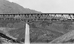
Between 1938 and 1945 , the Shasta Dam was built about 25 kilometers north of Redding on the upper reaches of the Sacramento River , just below the confluence with the Pit River . It has dammed Shasta Lake since 1944 , which forms three large tributaries through the flooded ends of the Sacramento, McCloud and Pit River valleys. This made it necessary to relocate the course of US Highway 99 and the connection of the Southern Pacific from Sacramento to Oregon . To cross the eastern Pit River branch, a new bridge for road and rail traffic was built shortly after the McCloud River branch by 1942. The double-decker bridge was at that time, with a height of over 150 meters above the original course of the Pit, the highest of its kind in the world. On its lower level, it carries one of originally two tracks and on the upper level four lanes of today's Interstate 5 .
The Southern Pacific was in 1996 in the Union Pacific Railroad (UP) that the bridge today for the rail freight uses, as well as the BNSF Railway , the route rights has in UP. Furthermore, the bridge since 1971 part of the route of the long distance train Coast Starlight from Amtrak , between Los Angeles and Seattle wrong. US Highway 99 in California has been largely part of Interstate 5 since 1964, including the Pit River Bridge .
In May 1953, the 1954 Pulitzer Prize for Photography was taken on the bridge by amateur Virginia M. Schau of the rescue of a truck driver by her husband. The tractor, manned by two men, had gotten over the perimeter of the bridge and was only held by the semi-trailer , which saved the two men from falling into the depths before they were rescued one after the other with the help of a rope.
description
The truss bridge consists of a central tannery girder that spans the four central bridge piers with lengths of 152 m, 192 m and 152 m. This is followed by three trusses of 86 m, 86 m and 43 m in length on the north side ; For the configuration on the south side, one 86-meter less beam was used. The total length of the truss bridge is 839 m and corresponds to the length of the lower railway level. The upper level of the carriageway is supplemented on both sides by several girder bridges that form a slight S-curve with the truss bridge. At the south end, a solid wall girder spans the track, which ends here in a tunnel. At the east end, four girders of the same design form a right turn; the track underneath swerves out of the overlying guide in a slight left curve. The total length of the carriageway level is therefore over 200 m longer and is 1094 m.
Around 17,000 tons of steel were used for the superstructure , with the structural elements being manufactured by the American Bridge Company in Gary and transported almost 3,500 km to the construction site by rail. The bridge piers supporting the superstructure are made of reinforced concrete , the two central pillars being up to 110 m high; the upper level of the carriageway is 152 m above the valley floor and the total of seven pillars are almost completely flooded when the reservoir is filled to the maximum.
literature
- A Diamond Anniversary: 75 Year Old Bridge Still in Use Today. AB Connections, No. 1006, Spring 2017, p. 30 f.
Web links
- Pit River Bridge. HighestBridges.com
- Pictures of the Pit River Bridge. Calisphere, UC Libraries, California Digital Library.
Individual evidence
- ↑ a b c Pit River Bridge Construction. California Highways and Public Works, Vol. 19, No. 3, March 1941, pp. 14 f.
- ↑ a b Grading Completed on Relocation of US 99 Shasta Dam Reservoir Unit of Central Valley Project. California Highways and Public Works, Vol. 19, No. 10, October 1941, pp. 1-3 and 6th
- ^ Pit River Bridge: Financial Impact Study of Interstate 5 Closure from a Catastrophic Failure. California Department of Transportation, September 2012.
- ^ Ranjit Dhaliwal: Rescue on Pit River Bridge. The Guardian, June 12, 2013, accessed May 11, 2018.
- ^ Heinz-Dietrich Fischer: Key Images of American Life: Pulitzer Prize Winning Pictures. LIT Verlag Münster, 2015, ISBN 978-3-643-90518-5 , p. 122.


