
Planegger Strasse (Munich)
| Planegger Street | |
|---|---|
|
|
|
_Planegger_Stra%C3%9Fe_-_S%C3%BCden.JPG) |
|
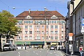
| Place name sign and the beginning of Planegger Strasse | |
| Basic data | |
| State capital | Munich |
| Borough | Pasing-Obermenzing |
| Hist. Names | Würmtalstrasse, Oberbürgermeister-Wunder-Strasse |
| Name received | 1946 |
| Connecting roads | Pasinger Marienplatz , Pasinger Strasse (in Graefelfing ) |
| Cross streets | Institustraße, Ebenböckstraße, Bodenstedtstraße, Am Klostergarten, Peter-Putz-Straße, Engelbertstraße, Sollerbauerweg, Graefstraße, Blumenauer Straße, Weinbergerstraße, Kraillinger Weg, Karl-Hromadnik-Straße |
| Numbering system | Orientation numbering |
| use | |
| User groups | Pedestrian traffic , bicycle traffic , individual traffic , public transport |
| Road design | asphalt |
| Technical specifications | |
| Street length | 1.6 km |
The Planeggerstraße is an old route in Munich district Pasing , the main axis of the village center of Pasing forms.
history
As a village street, Planegger Straße was originally occupied on both sides with gabled farmhouses . This development is most likely to have been preserved on the east side in the outer basic features (because of the conversion of the building). Most of the Einfirsthöfe, which were renovated in the 19th century , originally consisted of a residential part facing the street and a rear commercial part in which the stable , threshing floor and barn were housed.
After the abandonment of agriculture , which began in the second half of the 19th century, many of these farmhouses were converted and changed. Urban structures such as villas and apartment buildings were built around 1900 and intensified after the Second World War .
Due to the large number of new buildings that did not take into account the established village structure, the overall picture of Planegger Strasse appears very inconsistent.
The west side of Planegger Strasse is dominated at the beginning by the long front of the building complex (Planegger Strasse 4/6 and Institutstrasse 1/3) of the Englische Fräulein . The former southern end of the village is marked on the Würm side by Gatterburg Castle .
Outside of these old buildings, the now defunct paper mill in Munich-Dachau stood on Planegger Strasse, which built a tenement house for its employees and workers at Planegger Strasse 28/32 in 1906.
Marienplatz in Pasing as seen from Planegger Strasse

Former farmhouse at Planegger Strasse 15, built in the 19th century

Villa Planegger Strasse 9, built in 1896

Apartment building at Planegger Strasse 113 from the 1980s


Architectural monuments
See: List of architectural monuments in Pasing
See also
literature
- Denis A. Chevalley, Timm Weski: State Capital Munich - Southwest (= Bavarian State Office for Monument Preservation [Hrsg.]: Monuments in Bavaria . Volume I.2 / 2 ). Karl M. Lipp Verlag, Munich 2004, ISBN 3-87490-584-5 , p. 509-510 .
Web links
Individual evidence
- ^ Source to Planegger Straße. Retrieved February 25, 2020 .
- ^ Hans Dollinger: The Munich street names. 3. Edition. Ludwig Verlag, Munich 1996, ISBN 3-517-01986-0 .
Coordinates: 48 ° 8 ′ 39 ″ N , 11 ° 27 ′ 28.5 ″ E