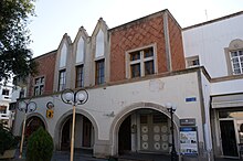
Platia Agias Paraskevis
The Platia Agias Paraskevis ( Greek Πλατεία Αγίας Παρασκευής Platía Agías Paraskevís , German 'Agia-Paraskevi-Platz' ) was created in 1935, after the great earthquake of 1933, which destroyed significant parts of the historical city of Kos on the island of Kos .
Surname
The name of the square is derived from the church of Agia Paraskevi , which is located slightly above . During the Italian occupation the square ( Italian Piazza degli Arancia / della Erbe , 'Square of the Orange Tree / Square of Herbs' ) was called.
location
The square is about 11 meters above sea level in the immediate vicinity of the Platia Eleftherias ( Πλατεία Ελευθερίας Freedom Square ). Spatially separated by the market hall of Kos, built in 1934 and standing transversely ( Δημοτική Αγορά Dimotikí Agorá Mercato delle Erbe ).
Community center
The town house on Platia Agias Paraskevis was built during the Italian occupation of the islands . The style can also be found on the Platia Eleftherias at the House of the Fascists ( Casa del Fascio ) and the Archaeological Museum , at the Governor's Palace of Kos at the port of Kos , a little less at the market hall. The style of this town house is indicative of the architectural style of the period from 1923 to 1943 of the Italian occupation of the Dodecanese islands. The style of the architecture was adapted according to the ideas of the new rulers and cleaned of "oriental influences" and carried out based on the Roman Empire in connection with fascist "ideals".
literature
- Nikos Varelas: Kos. DumontExtra, DuMont Buchverlag Cologne 2002. ISBN 3-7701-5759-1
Web links
Individual evidence
- ^ Italian Architects and Scholars in the Levant. The case of Rhodes and the Dodecanese Islands under the Italian Fascist Rule , p. 94.
- ↑ This is especially true after Cesare Maria De Vecchi replaced the previous governor Mario Lago of the Italian Aegean Islands ( Dodecanese ) in 1936 (see Marc Dubin: The Dodecanese and the East Aegean Islands, p. 436ff).
Coordinates: 36 ° 53 ′ 33.4 ″ N , 27 ° 17 ′ 19.3 ″ E


