
Kos (city)
|
Municipality of Kos Δημοτική Ενότητα Κω (Κως) |
|||
|---|---|---|---|
|
|||
| Basic data | |||
| State : |
|
||
| Region : |
South Aegean
|
||
| Regional District : | Kos | ||
| Municipality : | Kos | ||
| Geographic coordinates : | 36 ° 54 ′ N , 27 ° 17 ′ E | ||
| Height above d. M .: | 15 m (average) |
||
| Area : | 67.200 km² | ||
| Residents : | 19,432 (2011) | ||
| Population density : | 289.2 inhabitants / km² | ||
| Code No .: | 640101 | ||
| Structure: | 1 municipality | ||
| Website: | www.kos.gr | ||
| Location in the municipality of Kos and in the regional district of Kos | |||
 |
|||

The city of Kos ( Greek Κως ( f. Sg. )) Is the administrative seat of the Greek island and municipality of the same name , as well as the seat of the regional district of Kos . Since the administrative reform in 2010 , the city has formed the Kos district of the same name ( Dimotiki Kinotita Ko Δημοτική Κοινότητα Κω) and the Kos district ( Dimotiki Enotita Ko Δημοτική Ενότητα Κω). Continuous settlement in the urban area has been documented since the end of the Neolithic Age.
location
The municipality of Kos occupies an area of 67,200 km² in the east of the island. The city district of Dikeos borders to the west .
history
Settlement in the urban area extends to around the 3rd millennium BC. BC back. Between 2000 and 1600 BC The early Bronze Age settlement of Seraglio developed on a flat hill near the port . With an area of at least 7.5 hectares, it was one of the most important Minoan settlements outside of Crete . From 1450 BC Chr. Are Mycenaean influences detectable.
With more than 19,000 inhabitants, over 50% of the island's inhabitants live in the municipality. The city forms the economic and cultural center of the island and an important tourist center. A small minority of Sunni Muslims live in Platani to the south.
For the earthquake of July 21, 2017 see Kos island .
Attractions
Due to the millennia-long history, numerous important sites such as the Asklepieion of Kos or the St. John's fortress Neratzia from the 14th century can be visited in the city and the surrounding area . The earthquake of April 23, 1933, in which the inner city was largely destroyed, exposed the remains of the ancient city with the agora. The finds from the following excavations by Italian archaeologists are exhibited in the city's Archaeological Museum . Most of the excavation areas are freely accessible to visitors. In the center of Kos Town is also the place of Plantane the Tree of Hippocrates , after the ancient physician Hippocrates was named. The former hammam , also known as the salt depot, is located very close to the plane tree of Hippocrates . The remains of the Bab Gedid mosque are located near the old town .
On the Platia Eleftherias (also Eleftherias Square ) or Platia Agias Paraskevis ( Paraskevis Square ) there are architectural testimonies of the Italian occupation of the island in an Italian-fascist monumental style.
The church of Agios Nikolaos in Kos was badly damaged by the earthquake in 2017 and cannot be visited from the inside (as of 2019). The cathedral of Kos and Nisyros is located at the port and is the seat of the metropolis of Kos and Nisyros .
Other interesting sights include For example: Casa Romana , the Odeon , the Altar of Dionysus and the Gazi Hasan Pasha Mosque (also called the Loggia Mosque).
traffic
In addition to the ferry port north of the Johanniter fortress, the city has the smaller Mandraki port with excursion boats to the neighboring islands and Bodrum . In front of the port of Kos is the Gulf of Kos .
The central bus station is south of the city center.
The city has a well-developed network of cycle paths.
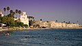
Beach with the Neratzia fortress in the background

Mandraki harbor

Gymnasion in the middle of the city (Western Archaeological Zone)

Eparchio
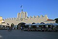
Market Hall and Platia Eleftherias


literature
- Madeleine Reincke, Hilke Maunder, Dieter Luippold: Kos. (= Baedeker Alliance travel guide ). 3rd, completely revised and redesigned edition. Baedeker, Ostfildern 2007, ISBN 978-3-8297-1155-5 , pp. 144-166.
Web links
- Kos town . In: Kos.gr
- Kos town . In: schwarzaufweiss.de
- Sights in Kos town and the surrounding area . In: Insel-Kos.info
Individual evidence
- ↑ Results of the 2011 census, Greek Statistical Office (ΕΛ.ΣΤΑΤ) ( Memento from June 27, 2015 in the Internet Archive ) (Excel document, 2.6 MB)