
Unity Square (Potsdam)

The Platz der Einheit ( Wilhelmplatz until 1946 ) is one of the oldest squares in Potsdam , along with the Bassinplatz and the plantation . Created under the soldier king Friedrich Wilhelm I , the square is limited by the Wilhelmgalerie in the north, residential buildings in the east, the street Am Kanal in the south and Friedrich-Ebert-Straße in the west. It is an important hub for local public transport .
Until 1950 there was a statue of Friedrich Wilhelm III on the square . In the northeast is the Bassinplatz with the Peter and Paul Church and the French Church , in the southeast the Old Market with the Nikolaikirche and the city palace . Its current name refers to the forced unification of the SPD and KPD to form the SED , which is why a renaming is discussed again and again.
history
Today's Unity Square is one of the oldest squares in the city. Originally there was a large expanse of water at the site of today's square, called the Lazy Lake. In the course of the first city expansion by the soldier king Friedrich Wilhelm I , this lake was filled in from 1724 and gradually rebuilt with town houses. The reclamation of the square was thus also a fight against nature, the boggy subsoil prevented further development of the square at that time.
From 1831 the terrain had to be filled up again, the horticultural master Peter Joseph Lenné redesigned the square. It was finally named Wilhelmplatz after King Friedrich Wilhelm II . In 1845 a bronze statue of King Friedrich Wilhelm III was erected in the middle of the square . , created by the Berlin sculptor and Rauch student August Kiß , was ceremoniously unveiled. In 1862 Lenné reworked it for Wilhelmplatz, adding two rows of trees and diagonal paths. During the Second World War, large parts of the peripheral buildings were destroyed, including the palace-like structure on the north side and the synagogue before that. The place was then used for agriculture.
In March 1946, the Potsdam magistrate renamed Wilhelmplatz to Platz der Einheit with reference to the compulsory merger of the SPD and KPD into the SED . Since the fall of the Wall, there have been repeated discussions about renaming the square. The bronze statue of Friedrich Wilhelm III. was melted down during the communist iconoclasm in 1950. In the years 1929 and 1979, reductions had to be compensated for. On the occasion of the BUGA 2001 , the square was redesigned and more closely based on the Lenné original. All of the city's tram lines cross at the square .

Wilhelmplatz 1776, view in north direction
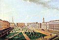
Wilhelmplatz 1776, looking south

Before 1945, looking south-east

Construction of the war-damaged main post office in 1949

1962, view of the still undeveloped northern part
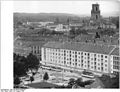
New buildings on the west side in 1963, the garrison church in the background


.jpg)


description
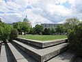
The square of the unit is a large, rectangular square with a floor area of around 250 by 150 meters. Its design combines classic and modern architecture with large lawns and rows of trees. The most striking feature is the X-shaped cross of paths that runs through the middle of the lawn rectangle. In the dark the stairs are illuminated with a bluish tinge. The neo-baroque post office building erected between 1879 and 1900 and the houses on the west side have been preserved from the historical peripheral development .
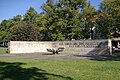
The memorial for the anti-fascist resistance fighters is located on the southeast side of the square . Another memorial to the unknown deserters was erected in 1990 in the southwest area. The south side of the square is dominated by the main building of the Potsdam City and State Library . This is a modern building from the 1960s that was extensively renovated and redesigned in 2013. The Wilhelmgalerie from the early 1990s now takes up the entire north side . The building with its glass-roofed inner courtyard is used by shops, bars and exhibitions. Its design is sometimes criticized as being too simple. The west side is formed by classical residential buildings, on the east side there are modern residential buildings and the post office.

View to the north with Wilhelmgalerie
Facing south
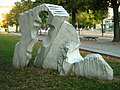
Memorial for the victims of fascism
Deserters Monument

Post office on the southeast corner of the square
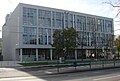
Library building


See also
literature
- Friedrich Mielke : Potsdam architecture - the classic Potsdam. Propylaen-Verlag, Berlin 1981, ISBN 978-3-549-06648-5 .
- Frank Bauer, Hartmut Knitter, Heinz Ruppert: Destroyed, forgotten, displaced - military buildings and military monuments in Potsdam. Mittler-Verlag, Berlin 1993, ISBN 978-3-8132-0413-1 .
- Klaus Arlt: The street names of the city of Potsdam - history and meaning. Association for Culture and History of Potsdam, 2010.
Web links
- Unity Square - State Capital Potsdam
Individual evidence
- ^ Klaus Arlt: The street names of the city of Potsdam. History and meaning . Dedicated to the researcher of the historical Potsdam city topography, Ing. Hermann Fellien. In: Announcements from the Sanssouci Association - Association for Culture and History of Potsdam . 4th year, no. 4 . Potsdam 1999, p. 57 ( aip.de [PDF; 345 kB ; accessed on January 12, 2017]).
- ↑ Wimmer, Clemens Alexander: The place of unity in Potsdam. Redesign as an end in itself, in: De Jong, Erik [Hrsg., U. a.]: The garden - a place of change. Perspektiven für die Denkmalpflege, Zurich 2006, pp. 229–238, here: p. 229.
- ↑ https://www.pnn.de/potsdam/nachrichten/22203624.html
- ↑ http://www.helmutcaspar.de/aktuelles17/gesch17/potsdam.htm
Coordinates: 52 ° 23 ′ 54 ″ N , 13 ° 3 ′ 32 ″ E