Porcupine River
| Porcupine River | ||
|
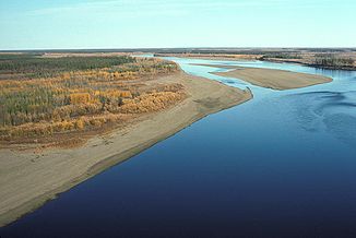
Porcupine River in the Yukon Flats National Wildlife Refuge |
||
| Data | ||
| Water code | US : 1416403 | |
| location | Yukon ( Canada ), Alaska ( USA ) | |
| River system | Yukon River | |
| Drain over | Yukon River → Bering Sea | |
| confluence | from Fishing Branch and Miner River , approximately 6 miles west of Whitestone Village 66 ° 27 ′ 26 ″ N , 138 ° 34 ′ 40 ″ W |
|
| muzzle | at Fort Yukon in the Yukon River coordinates: 66 ° 35 ′ 3 " N , 145 ° 20 ′ 2" W 66 ° 35 ′ 3 " N , 145 ° 20 ′ 2" W |
|
| Mouth height |
126 m
|
|
| length | 721 km | |
| Catchment area | 117,900 km² | |
| Outflow at the level at the mouth |
MQ |
650 m³ / s |
| Left tributaries | Cody Creek , Bluefish River , Black River , Grass River , Sucker River | |
| Right tributaries | Whitestone River , Bell River , Driftwood River , Old Crow River , Coleen River , Sheenjek River | |
| Communities | Old Crow , Fort Yukon | |
The Porcupine River ( Porcupine : English for tree prickers ) is a 721 km long river in the Canadian Yukon Territory and Alaska .
geography
Its source rivers, the Miner River and Fishing Branch , arise in the West Nahoni Mountains and in the Porcupine River Ranges to the north of it . They unite not far from Whitestone Village , on the border of the Ni'iinlii Njik (Fishing Branch) Territorial Park . From there the Porcupine River first flows northwards, then in a south-westerly direction, passes the village of Old Crow and flows into the Yukon River near Fort Yukon in Alaska . In the lower reaches the river flows through the Yukon Flats National Wildlife Refuge . The catchment area of the Porcupine River is 117,900 km², of which 61,400 km² are in Canada.
General
The porcupine caribou herd, which is threatened by the planned oil production in the Arctic National Wildlife Refuge in Alaska, is named after the river.
The oldest (but also controversial) evidence of human habitation in North America was found in a cave at a tributary of the Porcupine River. Large numbers of animal bones were found in the Bluefish Caves that had been worked by humans. By radiocarbon dating their age has been dated to 25,000 to 40,000 years, several thousand years earlier than was the first human settlements in North America.
Web links
Individual evidence
- ^ River Porcupine River in the Geographic Names Information System of the United States Geological Survey
- ↑ a b c Rivers. The Atlas of Canada
- ↑ Largest Rivers in the United States. (PDF; 648 kB) USGS - Water Fact Sheet
- ^ Jacques Cinq-Mars: The Significance of the Bluefish Caves in Beringian Prehistory . civilization.ca, February 2001
