Portoviejo
| Portoviejo | ||
|---|---|---|
|
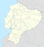
Coordinates: 1 ° 3 ′ S , 80 ° 27 ′ W Portoviejo on the map of Ecuador
|
||
| Basic data | ||
| Country | Ecuador | |
| province | Manabí | |
| Residents | 171,847 (2001) | |
| City insignia | ||
| Detailed data | ||
| height | 136 m | |
| prefix | 5 | |
| Time zone | UTC -5 | |
| City Presidency | Patricia Briones | |
| Website | ||
Portoviejo is an Ecuadorian city.
The capital of the province of Manabí is located approx. 20 kilometers from the Pacific coast inland. It is an important center for cattle breeding and the cultivation of coffee and cotton .
The city was founded on March 12, 1535 by the Spanish captain Francisco Pacheco as Villa Nueva de San Gregorio de Portoviejo .
Portoviejo is known for its former tamarind plantations. Therefore it is still called "City of the Royal Tamarind Trees" (Ciudad de los Reales Tamarindos) . Today in Ecuador Ceibo named kapok trees dominate the landscape.
Curiosity
In today's district Picoazá 1967 won foot powder the local elections . Leaflets from an aggressive advertising campaign were modeled on the official ballot papers and were thrown in the ballot boxes by the thousands across the country. US media in particular reported about it.
Web links
Individual evidence
- ↑ Foot Powder Produces Headaches in Ecuador. The New York Times , July 17, 1967, accessed October 12, 2017 .
- ↑ Ad Campaign for Foot Powder Stirs Trouble. Minneapolis Star Tribune , July 20, 1967 issue, p. 27.


