Prager Strasse (Bremerhaven)
| Prague street | |
|---|---|
| Street in Bremerhaven | |
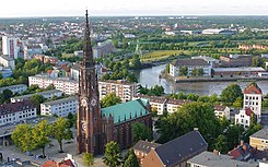
| Big church , behind it the Prager Straße | |
| Basic data | |
| city | Bremerhaven |
| district | center |
| Created | around 1849 |
| Cross streets | Löningstrasse, Mittelstrasse, Kirchenstrasse, Mühlenstrasse, Keilstrasse |
| use | |
| User groups | Cars, bikes and pedestrians |
| Road design | two lane road |
| Technical specifications | |
| Street length | 500 meters |
The Prager Straße is a central access road in Bremerhaven , middle (South). It runs parallel to Bürgermeister-Smidt-Strasse in a south-north direction from Löningstrasse to Keilstrasse.
The cross streets and the connecting streets were named u. a. as Löningstrasse (?), Mittelstrasse after its location around 1850, when the first three cross streets were created, Kirchenstrasse after the Great Church there, Mühlenstrasse (?), Keilstrasse (?); otherwise see the link to the streets.
history
Surname
In 1849 the street was called Langestrasse . The renamed Prager Strasse was named after the capital of the Czech Republic . In Alt-Bremerhaven some streets were named after towns of the former Austro-Hungarian monarchy ( Grazer Straße , Preßburger Straße)
development
After the ports were built (from 1827), Bremerhaven slowly expanded around 1850 to the east in the direction of Geeste and to the north. After Leher Heerstraße (from 1865 Mayor-Smidt-Straße ), the Markt-, Lange-, Kurz- and Grabenstraße and Deichstraße were built around 1850 and the Deich-, Post- (An der Karlstadt), Geest- (today Löning-) Mittel-, Kirchen-, Mühlen- and Keilstraße and in 1864 Schleusenstraße (today Lloydstraße ). The Protestant Mayor Smidt Memorial Church (Great Church) was built in 1855. In 1867 the new municipal school building was inaugurated as a primary school on Langen Strasse.
Seppl Kein and Zum 1/2 l Fritz were two bars on today's Prager Straße (at that time Lange Straße), in which communists and social democrats frequented in the 1920 / 30s.
In World War II, almost all the houses were destroyed. The reconstruction is characterized by the houses from the 1950s and 60s.
traffic
A grid of streets was laid out around 1849. Long street in the center. Since 1881 there has been a horse-drawn tram on the nearby Bürger . From 1898 to 1908 it was converted into an electric tram with 5 lines.
In BremerhavenBus' local transport, routes 501, 502, 505, 506, 508, 509 and 511 run on the Bürger in parts or entirely, as well as the ML / NL lines on weekend nights.
Buildings and facilities
The street mainly has three to four storeys. A few single-storey buildings disturb the street scene.
Notable buildings and facilities
- No. 47 and 49: Two 2-storey, listed classicist residential and commercial buildings from around 1850 (see residential buildings on Prager Strasse )
- Kirchenstrasse No. 13 at the corner of Prager Strasse: 3-storey. Residential and commercial building from around 1900 with two distinctive central bay windows
- No. 53: 2-storey, listed historicizing residential and commercial buildings from around 1865, today with holiday apartments.
- Between Kirchenstrasse and Mühlenstrasse: Evangelical, neo - Gothic three-aisled , 80 meter high Mayor Smidt Memorial Church from 1855 based on plans by Simon Loschen, Bremen for the United Protestant Congregation ; Badly damaged in 1944 and rebuilt by the architect Karl Franzius by 1960 .
- No. 71: 5-sch. Residential and commercial building with the company medical center in Bremen
- Between Mühlenstraße and Keilstraße: 4-storey. Group of houses from around 1960, the west-liuchen buildings in open row construction
literature
- Harry Gabcke , Renate Gabcke, Herbert Körtge, Manfred Ernst: Bremerhaven in two centuries; Volumes I to III from 1827 to 1991. Nordwestdeutsche Verlagsgesellschaft, Bremerhaven 1989/1991, ISBN 3-927857-00-9 , ISBN 3-927857-37-8 , ISBN 3-927857-22-X .
Individual evidence
- ^ H. Thätjenhorst and A. Duntze: Map of the area of the free Hanseatic city of Bremen. 1851., here edition. 1860.
- ^ Paul Homann: Bremerhaven route networks. In: Bremerhaven route networks. Retrieved September 15, 2019 .
- ^ Monument database of the LfD
- ^ Monument database of the LfD
- ^ Monument database of the LfD
- ^ Monument database of the LfD
Coordinates: 53 ° 32 ′ 39.1 ″ N , 8 ° 34 ′ 50.8 ″ E


