Brag of crags
| Brag of crags | ||
|---|---|---|
|
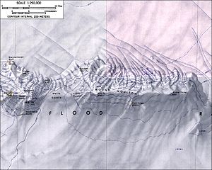
Topographic map (1: 250,000) of the Flood Range with the Prahl Crags (bottom center) |
||
| location | Marie Byrd Land , West Antarctica | |
| Mountains | Flood range | |
| Coordinates | 76 ° 4 ′ 0 ″ S , 134 ° 43 ′ 0 ″ W | |
|
|
||
The Prahl Crags are 2750 m high rocky outcrops in the West Antarctic Marie-Byrd-Land . In the Flood Range, they rise up on the southern slopes of the Mount Moulton massif .
The United States Geological Survey mapped them based on their own surveys and aerial photographs of the United States Navy from 1959 to 1966. The Advisory Committee on Antarctic Names named them in 1974 after the glaciologist Sidney R. Prahl, who between 1971 and 1972 studied the dynamics of the Antarctic Had examined the ice sheet northeast of Byrd Station .
Web links
- Prahl Crags in the Geographic Names Information System of the United States Geological Survey (English)
- Prahl Crags on geographic.org (English)

