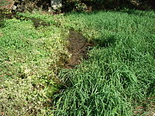
Premerzhofen spring
| Premerzhofen spring | |||
|---|---|---|---|
 Premerzhofen spring |
|||
| location | |||
| Country or region | District of Neumarkt in der Oberpfalz , Upper Palatinate ( Bavaria ) | ||
| Coordinates | 49 ° 3 ′ 21 ″ N , 11 ° 36 ′ 3 ″ E | ||
|
|||
| geology | |||
| Mountains | Franconian Alb | ||
| Source type | Karst springs | ||
| Exit type | Sources of falls | ||
| Hydrology | |||
| River system | Danube | ||
| Receiving waters | White Laber → Altmühl → Danube → Black Sea | ||
Coordinates: 49 ° 3 ′ 21 ″ N , 11 ° 36 ′ 3 ″ E
The Premerzhofener Quelle is a karst spring designated as a natural monument near Breitenbrunn in the Upper Palatinate .
description
The source is north of Dietfurt in the valley of the White Laber (lower citizens Laber). There are several sources of falls that arise directly from the rock. The source area in front of the exit points is covered with aquatic plants. The pouring of the spring depends heavily on precipitation and can rise to several hundred liters per second after heavy rain or snowmelt . Numerous heavy hunger wells can escape in their immediate vicinity . The flowing stream is used for fish farming and flows into the White Laber after about 240 m.
Geotope
The source is designated by the Bavarian State Office for the Environment as geotope 373Q002. See also the list of geotopes in the Neumarkt district in the Upper Palatinate .
See also
Web links
- Karst spring Premerzhofen (PDF; 190 kB)
- Premerzhofen spring
Individual evidence
- ↑ www.wasserhoehlenforschung.de (with video of the heavily pouring Premerzhofen spring at the bottom of the page)
- ↑ Google Earth
- ↑ Geotope: Karst spring Premerzhofen (accessed on August 22, 2013; PDF; 190 kB)

