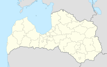
Priekuļi
| Priekuļi | ||
|---|---|---|
 Help on coat of arms |
|
|
| Basic data | ||
| State : |
|
|
| Landscape: | Livonia ( Latvian : Vidzeme ) | |
| Administrative district : | Priekuļu novads | |
| Coordinates : | 57 ° 19 ' N , 25 ° 22' E | |
| Residents : | 2,307 | |
| Area : | ||
| Population density : | ||
| Height : | 117 m | |
| Website: | www.priekuli.lv | |
| Post Code: | ||
| ISO code: | ||
Priekuļi (German: Freudenberg) is a village in northern Latvia and the center of the administrative district of the same name (Latvian: Priekuļu Novads ). The distance to the former district town of Cēsis is about 7 km. In 2015, 2307 inhabitants were registered.
history
The present-day village originated in the area of the Freudenberg estate, which was created in 1526 . With the establishment of an agricultural school in 1910 and an agricultural institute with an experimental station in 1919, the town grew and in 1990 received its own municipal administration.
In 1996, the curricula of the state agricultural technical center were revised according to the Triesdorf model .
See also
literature
- Hans Feldmann , Heinz von zur Mühlen (Hrsg.): Baltic historical local dictionary, part 2: Latvia (southern Livland and Courland). Böhlau, Cologne 1990, ISBN 3-412-06889-6 , p. 171.
- Astrīda Iltnere (ed.): Latvijas Pagasti, Enciklopēdija. Preses Nams, Riga 2002, ISBN 9984-00-436-8 .
Individual evidence
- ↑ Vietvārdu datubāze
- ↑ Hans Feldmann, Heinz von zur Mühlen (ed.): Baltic historical local dictionary, part 2: Latvia (southern Livland and Courland). Böhlau, Cologne 1990, p. 171.
