
Puig de Ferrutx
| Puig de Ferrutx | ||
|---|---|---|
 |
||
| height | 523.4 msnm | |
| location | Mallorca , Spain | |
| Mountains | Serres de Llevant | |
| Coordinates | 39 ° 43 '4 " N , 3 ° 17' 10" E | |
|
||
| Type | Rock peaks | |
| rock | limestone | |

The Puig de Ferrutx is 523 meters high, according to other information 528, 522 or only 519 meters, the second highest mountain of the Serres de Llevant ("Mountains of the East") on the Spanish Balearic island of Mallorca . It is located in the northwestern part of the landscape zone ( comarca ) Llevant .
The Puig de Ferrutx belongs to the municipality of Artà and is located near the western border of the municipality. The closest village is Colonia de Sant Pere, northwest of the mountain, also part of the municipality of Artà.
Location and surroundings

The Puig de Ferrutx is located in the mountains of Artà ( Catalan Serra Artana or Massís d'Artà ), part of the Serres de Llevant and its northernmost foothills. The highest point of this mountain range, the Puig Morei , is not quite six kilometers northeast of the Puig de Ferrutx .
Due to its striking appearance, rising from the plain of the Plà de Mallorca and near the Bay of Alcúdia (Badia de Alcúdia) , the mountain can be recognized from afar from the west. Its western rock head is known as the Bec de Ferrutx (Bec = peak) and is the highest point of the Puig de Ferrutx with 523 meters . To the east of it there is a survey point , a geodetic column , on the long ridge about 300 meters away . This point, which is only a few meters deeper at 517 meters, is called Ferrutx , and according to other sources it is also called Ferruxet .
Is limited, the massif of the Puig de Ferrutx next level in the West, on which adjacent the estate sa Devesa is, by the 412 meter high mountain pass Coll d'en Pelat in the northeast. This separates the Puig de Ferrutx from the 485 meter high Puig d'en Pelat . The closest elevations are the Puig d'en Xoroi (479 meters) in the north, the Puig d'en Borràs (382 meters) in the south and the Puig Fonament (354 meters) in the east. About two kilometers south-east of the Puig de Ferrutx , the 194-meter-high pass Coll de Morell forms the border between the Artà and the Calicant Mountains (Serra de Calicant) , also part of the Serres de Llevant .
- Views of the Puig de Ferrutx
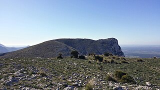
View from Puig d'en Pelat to the east of the Ferrutx ridge
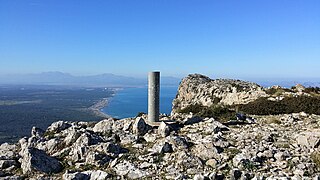
Geodetic column es Ferruxet (517 meters ) on the ridge

South-west side of the summit of the Puig de Ferrutx

View from Puig de Ferrutx to the bay of Alcúdia
_Puig_de_Ferrutx.jpg)
_Puig_de_Ferrutx.jpg)
_Puig_de_Ferrutx.jpg)
_Puig_de_Ferrutx.jpg)
Individual evidence
- ↑ a b Hiking in Mallorca (Senderisme a Mallorca). Mallorca Island Council ( Consell de Mallorca ), accessed on February 16, 2015 (interactive map).
- ↑ a b Mapa urbanistic de les Illes Balears. Govern de les Illes Balears , accessed on 13 May 2015 (interactive map).
- ↑ Visualitzador IDEIB (Infraestructura de dades espacial de les isles baleares). Govern de les Illes Balears , accessed on 13 May 2015 (interactive map).
- ↑ IBERPIX. Instituto Geográfico Nacional - Gobierno de España , accessed on May 13, 2015 (interactive map).
- ↑ Compass map: Mallorca - 1: 75,000. Verlag Kompass Karten , Rum / Innsbruck September 2007, ISBN 3-85491-870-4
- ↑ Situación territorio y clima. www.arta-web.com, archived from the original on April 15, 2009 ; Retrieved May 7, 2010 .
- ↑ To the Puig de Ferrutx: From here you can see everything. Retrieved on September 5, 2014 (article in Mallorca Zeitung).
- ↑ Ermita de Betlem - Bec de Ferrutx (522 m). Retrieved on September 5, 2014 (article from mallorca-erleben.info).