
Pulai (river)
| Pulai | ||
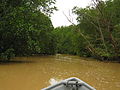
 Mouth of the Pulai with the port (middle) and the second link to Singapore at the bottom right. |
||
| Data | ||
| location | Malaysia | |
| River system | Pulai | |
| origin | at Gunung Pulai | |
| muzzle | in the Strait of Johor Coordinates: 1 ° 20 ′ 7 ″ N , 103 ° 33 ′ 0 ″ E 1 ° 20 ′ 7 ″ N , 103 ° 33 ′ 0 ″ E |
|
| Mouth height |
0 m
|
|
| length | approx. 22 km | |
| Catchment area | 362 km² | |
The Pulai ( Malay Sungai Pulai ) is a small river at the southwest end of the Malay Peninsula in the state of Johor .
course
The river has a length of approx. 22 km. Its source is near the town of Pekan Nenas, south of Mount Gunung Pulai . It is very branched and forms the border between the two districts of Pontian and Johor Bahru . Most of the river bed runs through mangrove forest . At the mouth it is 2.8 km wide. The port of Tanjung Pelepas is located on the east bank of the delta .
Species protection
In the estuary is the largest field of seagrass in Malaysia, which extends to the island of Pulau Merambong . Lately, the river has appeared in the media mainly because of the environmental initiative "SOS" (Save Our Seahorses), whose lead animal is the spotted seahorse ( Hippocampus kuda ).
photos

Mouth of the Pulai with the port on the left and the power station on the right of the mouth
The Pulai in its upper reaches

Gunung Pulai from the river

Fish farm on the river


Individual evidence
- ↑ Ministry of Natural Reserves and Environment, Malaysia: National Water Resources Study, Vol. 17 - Johor ( Memento of the original from January 5, 2016 in the Internet Archive ) Info: The archive link was inserted automatically and has not yet been checked. Please check the original and archive link according to the instructions and then remove this notice. (PDF; 60.7 MB) page 73
- ↑ Saveing The Seahorses Means Saving the Sea. Archived from the original on November 11, 2011 ; accessed on January 31, 2011 .