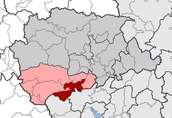
Pyli (municipality)
|
Pyli parish Δημοτική Ενότητα Πύλης (Πύλη) |
||
|---|---|---|
|
|
||
| Basic data | ||
| State : |
|
|
| Region : |
Thessaly
|
|
| Regional District : | Trikala | |
| Municipality : | Pyli | |
| Geographic coordinates : | 39 ° 27 ' N , 21 ° 29' E | |
| Height above d. M .: | 382 m (average) |
|
| Area : | 100.075 km² | |
| Residents : | 4,492 (2011) | |
| Population density : | 44.9 inhabitants / km² | |
| Code No .: | 260301 | |
| Structure: | 7 local communities | |
| Located in the municipality of Pyli and the Trikala regional unit | ||
Pyli ( Greek Πύλη ( f. Sg. )) Is a district of the municipality of the same name in the Greek region of Thessaly . Until the Kallikratis reform in 2011, it formed an independent community.
location
The municipality of Pyli extends in the south of the municipality of Pyli to 100.075 km². Neighboring parishes are Ethikes in the north, Pialia and Gomfi in the east, and Neraida and Myrofyllo in the west. The communities of Argithea and Mouzaki border in the south .
Administrative division
On the occasion of the municipality reform in 1997 , the municipality of Pyli was formed from the merger of seven rural municipalities. With the implementation of the Kallikratis program, this in turn became one of seven municipal districts in the newly formed municipality of Pyli .
| Local community | Greek name | code | Area (km²) | 2001 residents | Residents 2011 | Villages and settlements |
|---|---|---|---|---|---|---|
| Pyli | Τοπική Κοινότητα Πύλης | 26030101 | 17,478 | 1838 | 1873 | Pyli |
| Agios Vissarion | Τοπική Κοινότητα Αγίου Βησσαρίωνος | 26030102 | 12,427 | 775 | 641 | Agios Vissarion |
| Agios Prokopios | Τοπική Κοινότητα Αγίου Προκοπίου | 26030103 | 4,976 | 153 | 87 | Agios Prokopios |
| Kotroni | Τοπική Κοινότητα Κοτρωνίου | 26030104 | 13.002 | 507 | 375 | Kotroni, longies |
| Paleokarya | Τοπική Κοινότητα Παλαιοκαρυάς | 26030105 | 30.410 | 357 | 117 | Ano Paleokarya, Kato Paleokarya, Mesi Paleokarya |
| Petrochori | Τοπική Κοινότητα Πετροχωρίου | 26030106 | 5.404 | 220 | 95 | Petrochori |
| Ropoto | Τοπική Κοινότητα Ροποτού | 26030107 | 16.378 | 641 | 339 | Ropoto, Agios Dimitrios, Agios Ioannis, Longies, Panagia, Polythea, Tsekoura |
| total | 260301 | 100.075 | 4492 | 3527 | ||
Individual evidence
- ↑ Results of the 2011 census, Greek Statistical Office (ΕΛ.ΣΤΑΤ) ( Memento from June 27, 2015 in the Internet Archive ) (Excel document, 2.6 MB)
- ↑ Κεντρική Ένωση Δήμων και Κοινοτήτων Ελλάδας (ΚΕΔΚΕ) Ελληνική Εταιρία Τοπικής Ανάπτυξης και Αυτοδιοίκησης (ΕΕΤΑΑ) (ed.): Λεξικό Διοικητικών Μεταβολών των Δήμων και Κοινοτήτων (1912-2001). 2 (Τόμος Β, λ – ω), Athens 2002, ISBN 960-7509-47-1 , p. 362

