
Quebrada de las Conchas

The Quebrada de las Conchas (German gorge of the mussels , also called Quebrada de Cafayate ) is an approximately 75 km long, relatively narrow section of the valley of the Río Guachipas in northwest Argentina , which is called here Río de las Conchas. Most of it lies in the La Viña department in the Salta province . The southern part belongs to the department of Cafayate . The gorge represents the main connection between the more extensive valleys of the Valle de Lerma and the Valles Calchaquíes .
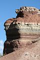
Stratification of the sandstone
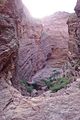
Garganta del Diablo

South exit of the gorge with Los Castillos to the left of the road


The Ruta Nacional 68 crosses the Quebrada de las Conchas over its full length. Coming from the north of the Valle de Lerma , south of Alemanía it enters the sometimes desert-like gorge, characterized by slopes of red conglomerates and sand , silt and clay stones . The rocks are continental deposits of the "middle" Cretaceous Period ( Cenomanium ), which are summarized under the name La Yesera Formation. In the gorge there are peculiar rock formations along the national road that were created by the erosion of the Cretaceous deposits, for example El Sapo ( The Toad ), El Fraile ( The Monk ) and El Obelisco ( The Obelisk ), as well as the Garganta del Diablo ( Devil's Throat ). The Anfiteatro ( amphitheater ) at the end of the Garganta del Diablo is known for its echo. A few kilometers north of Cafayate , the gorge opens into the valley of the Río Calchaqui near the rock formation Los Castillos ( The Castles ) . Los Medanos , a small, active dune field , is located near Cafayate, outside the gorge . The Ruta Nacional 68 leads through wineries and finally ends at the Ruta Nacional 40 .
Web links
Individual evidence
- ↑ Ignacio F. Sabino: Estratigrafía de la Formación La Yesera (Cretácico): Base del relleno sinrift del Grupo Salta, noroeste Argentina. Revista de la Asociación Geológica Argentina. Vol. 59, No. 2, 2004, pp. 330-340 ( online ).
Coordinates: 25 ° 55 ′ S , 65 ° 43 ′ W