Queve
|
Queve Cuvo |
||
|
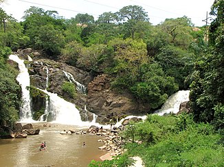
Binda Falls on the Queve |
||
| Data | ||
| location |
|
|
| River system | Queve | |
| source | 30 km east of the city of Huambo . 12 ° 42 ′ 46 ″ S , 16 ° 0 ′ 11 ″ E |
|
| Source height | 1800 m | |
| muzzle | about 12 km south of Porto Amboim in the Atlantic Coordinates: 10 ° 51 ′ 44 " S , 13 ° 47 ′ 50" E 10 ° 51 ′ 44 " S , 13 ° 47 ′ 50" E |
|
| Mouth height | 0 m | |
| Height difference | 1800 m | |
| Bottom slope | 3.6 ‰ | |
| length | 505 km | |
| Catchment area | 23,000 km² | |
| Right tributaries | Cuvira | |
The Queve or Cuvo is a river in Angola.
course
It rises 30 km east of the city of Huambo . It is in the same area as the Okawango , Kunene and Cutato springs . The river runs in a north-westerly direction and flows into the Atlantic about 12 km south of Porto Amboim . The Queve has a relatively narrow catchment area. With the exception of the Cuvira, all of its tributaries are very short.
Individual evidence
- ↑ Russian General Staff Map xd-33-2
- ^ AIP - Estudo de mercado sobre a provincia de Huambo
- ↑ US Army cards SC33 and SD33
