Quilotoa
| Quilotoa | ||
|---|---|---|
|
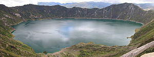
Caldera with crater lake |
||
| height | 3914 m | |
| location | Ecuador | |
| Mountains | To the | |
| Coordinates | 0 ° 51 ′ 0 ″ S , 78 ° 54 ′ 0 ″ W | |
|
|
||
| Type | Caldera | |
| Last eruption | 1280 (uncertain) | |
Quilotoa is the name of a caldera and the crater lake in it , and is also the westernmost volcano in the Ecuadorian Andes .
Today the highest point is 3914 m above sea level, the diameter of the caldera is 3 km. The last eruption may have occurred in 1280 . At that time, a massive eruption occurred (level 6 on the volcanic explosive index scale ), the lahar and pyroclastic current of which reached the Pacific . Since then, there has been a crater lake up to 250 m deep in the caldera with a green color caused by minerals . There are fumaroles at the bottom of the lake and hot springs on the east side of the volcano .
Quilotoa has been a popular tourist destination for some time: tourists mostly come from the nearby town of Zumbahua and pay admission for the view. The 5-hour hike around the caldera is also popular; In about 3 hours you can hike from the caldera to the lake and back.
Web links
- Quilotoa in the Global Volcanism Program of the Smithsonian Institution (English)
- Information for tourists at exploringecuador.com (English)
- Information for tourists at moon.com (English)

