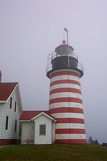
Quoddy Head State Park
The Quoddy Head State Park is a State Park in Washington County in the US state of Maine . The 219 hectare park is located six kilometers east of Lubec on a peninsula on the Grand Manan Channel and the Quoddy Channel at the easternmost point on the mainland of the state of Maine and thus the United States of America.
geography
The black, about 25 meter high cliffs of the park are dated to the Silurian and are about 420 million years old. They were formed when magma penetrated rocky layers beneath the ocean floor. The magma solidified into the dark, coarse-grained gabbro that is visible today , while the surrounding rock layers have eroded. The highest cliff in the park, High Ledge , is over 45 meters above sea level. In the Quoddy Channel between Campobello Island and West Quoddy Head there are strong ocean currents, the tidal range on the coasts can be over six meters. Off the coast is the bird-populated Sail Rock , which is considered the most easterly point in the United States.
climate
The West Qoddy Head Peninsula is often shrouded in mist when warm, humid air from inland meets the cold sea air. Due to the wind chill effect created by fog and sea breezes , it can be cool in the park even in midsummer.
Flora and fauna
A forest of black spruce and balsam firs grows on the thin layer of humus above the rocky subsoil, which is damp and muddy due to the climate . On the coast there are still trees covered with salt that died in the Groundhog Day storm on February 2, 1976, an extreme Nor'easter .
In the park area at West Quoddy Head and at Carrying Place Cove there are two moors with arctic and sub-arctic plants such as black crowberry , peat turf , laurel roses , Greenland leek and carnivorous plants such as sundew that are rare for this region . Due to erosion on the coast, a layer of peat over four meters thick is visible at Carrying Place Cove Moor , the moor is a National Natural Landmark .
The park offers some of the best game viewing in Maine. In summer visitors can off the coast humpback whales , minke whales and fin whales discover along with numerous eiders , scoters , long-tailed ducks , kittiwakes , gannets , Gray Plover , Ruddy Turnstone and sea beach runner . In spring and autumn, hundreds of waders gather in the bays Lubec Flats and Carrying Place Cove on the western park boundary . In winter you can see ducks, guillemots , razorbills and often bald eagles .
There are numerous mosquitoes and black flies in the park in late spring and summer . Visitors should also watch out for deer ticks .
history
The name Quoddy Head comes from the language of the Native Americans of the Passamaquoddy tribe and is translated as "fertile and beautiful place". The bay Carrying Place Cove got its name because the Indians have gathered here their canoes across the narrow peninsula here to the dangerous trip to West Quoddy Head avoid.
The first beacon at West Quoddy Head was erected in 1808, the current tower was built in 1858. In 1988 the tower was automated. The lighthouse has been managed by the Maine Bureau of Parks and Lands since 1998 and is part of the park. In 2002, the park's visitor center opened in the former lighthouse keeper's house, operated by the West Quoddy Head Light Keepers Association .
Because of its location, the state bought the park area from several private landowners in 1962 and established the state park.
Tourist facilities
The park is open from mid-May to mid-October. During this time, the park's museum and visitor center is also open daily. There is a picnic area in the park and four hiking and walking trails with a total length of eight kilometers lead through the park. Some of the trails offer spectacular views from the cliffs of the ocean and Grand Manan Island . The approximately 1.5 kilometer long Bog Trail leads as a footbridge through moor at West Quoddy Head. The beach can be reached via stairs from the picnic area.
literature
- Barbara Sinotte: Maine: A Guide to the State Parks, National Parks & Historic sites. Kindle Edition 2010
Web links
- State Park website
- State Park Brochure (PDF; 1.9 MB)
- Quoddy Head State Park on the United States Geological Survey's Geographic Names Information System
Individual evidence
- ↑ America's most easter point. Retrieved March 26, 2011 .
- ^ Quoddy Head State Park. Retrieved March 26, 2011 .
Coordinates: 44 ° 48 ′ 25.3 " N , 66 ° 58 ′ 2.9" W.

