
Río Anllóns
| Río Anllóns | ||
 Waterfall in Cerceda |
||
| Data | ||
| location | Galicia , A Coruña Province | |
| River system | Río Anllóns | |
| source | Hill in Parroquia Soandres in Laracha 43 ° 13 ′ 40 ″ N , 8 ° 26 ′ 20 ″ W |
|
| Source height | 480 m | |
| muzzle | in the Ría de Corme y Laxe coordinates: 43 ° 13 '50 " N , 8 ° 56' 44" W 43 ° 13 '50 " N , 8 ° 56' 44" W. |
|
| Mouth height | 0 m | |
| Height difference | 480 m | |
| Bottom slope | 8.8 ‰ | |
| length | 54.4 km | |
| Drain |
MQ |
9.9 m³ / s |
| Small towns | Cabana de Bergantiños , Carballo , Cerceda , Coristanco and Ponteceso | |
The Río Anllóns is a river in Galicia .
Word origin
There is a presumption that the name Anllóns comes from the Latin angulus , angle, and therefore comes from the fact that the river meanders in many turns.
geography
The river has its source in the municipality of Laracha near Parroquia Soandres on the Montemaior mountain at an altitude of 480 m. After 54.4 km it flows into the Ría de Corme y Laxe . On his way he crosses the areas of the municipalities of Laracha, Cerceda , Carballo , Coristanco , Ponteceso and Cabana de Bergantiños . Immediately after Ponteceso, it widens into a winding, slender estuary . A swamp area extends on the left bank.

Flood near Verdes
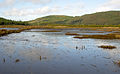
Swamp below Ponteceso

Estuary


The mean water flow of the Río Anllón is 9,931 m³ / s.
Tributaries
In its upper reaches, the Río Anllóns receives water from the Graña, Quenxe, Acheiro, Abaixo, Queo and Bertón streams. After passing Monte Neme, the waters of Gándara, Bandeira, Vao, Galvar, Portecelo and Batán flow to it. In the lower reaches, after crossing the Parroquia Verdes of the Coristanco municipality, he passes rapids. In the area of Ponteceso the Lourido flows into the Río Anllóns.
Individual evidence
- ^ Isidoro Millán González-Pardo: Toponimia de Ponteceso y de su municipio . In: Cuadernos de Estudios Gallegos . tape 41 , no. 106 , December 30, 1994, pp. 441-489 , doi : 10.3989 / ceg.1994.v41.i106.289 .