Río Deva (Cantabria)
| Río Deva | ||
|
Confluence of the Río Quiviesa with the Río Deva near Potes |
||
| Data | ||
| location |
Spain Cantabria |
|
| River system | Río Deva | |
| River basin district | Demarcación Hidrográfica del Cantábrico | |
| source | near Fuente Dé ( Cantabrian Mountains ) 43 ° 8 ′ 43 ″ N , 4 ° 48 ′ 36 ″ W |
|
| Source height | approx. 1100 m | |
| muzzle |
Ría de Tina Mayor → Biscay Coordinates: 43 ° 22'29 " N , 4 ° 31'7" W 43 ° 22'29 " N , 4 ° 31'7" W. |
|
| Mouth height | approx. 0 m | |
| Height difference | approx. 1100 m | |
| Bottom slope | approx. 17 ‰ | |
| length | 64 km | |
| Catchment area | 1195 km² | |
The Río Deva is an approximately 64 km long coastal river in the northern Spanish autonomous region of Cantabria . Its lower course forms the border with Asturias for a length of about five kilometers .
course
The Río Deva rises - depending on the amount of rain or meltwater available, at an altitude of approx. 1100 meters above sea level. d. M. - at the Fuente Dé cable car station in the Cantabrian Mountains and flows first in an easterly, then later in a northerly direction; at the town of Unquera it flows into the Ría de Tina Mayor , which opens after another two kilometers to the Bay of Biscay .
Places on the river
Tributaries
|
|
Attractions
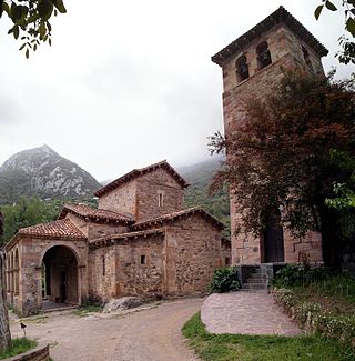
The upper course of the river in particular is scenic, partly gorge-like and popular with anglers ; the residents of the communities and villages on its banks offer holiday apartments ( casas rurales ) for rent. About one kilometer south of its central reaches (about three kilometers west of Potes ) is the medieval monastery of Santo Toribio de Liébana ; About nine kilometers northeast of Potes is the pre-Romanesque church of Santa María de Lebeña near the river.

