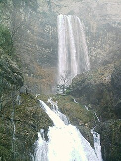
Río Mundo
| Río Mundo | ||
|
Source of the Río Mundo |
||
| Data | ||
| River system | Segura River | |
| Drain over | Río Segura → Mediterranean | |
| source | approx. 6 km south of Riópar, Albacete province 38 ° 27 ′ 0 ″ N , 2 ° 26 ′ 11 ″ W |
|
| Source height | approx. 1300 msnm | |
| muzzle | in the Río Segura coordinates: 38 ° 18 ′ 53 " N , 1 ° 40 ′ 9" W 38 ° 18 ′ 53 " N , 1 ° 40 ′ 9" W |
|
| Mouth height | approx. 300 msnm | |
| Height difference | approx. 1000 m | |
| Bottom slope | approx. 6.7 ‰ | |
| length | 150 km | |
| Catchment area | 766 km² | |
| Drain |
MQ |
20 m³ / s |
| Left tributaries | Río de la Vega, Río de los Vadillos, Río de Bogarra, Arroyo de Tobarra | |
| Right tributaries | Rambla de Dilar | |
| Reservoirs flowed through | Talave Reservoir, Camarillas Reservoir | |
The Río Mundo ( Eng . World River ) is a river in southeastern Spain. It rises below the high plateau Calar del Mundo south of the village of Riópar in the province of Albacete . From there it flows eastwards largely parallel to the Río Segura to the south , into which it finally flows after 150 km.
The Río Mundo has two reservoirs, the Talave reservoir in the middle reaches with a capacity of 34 cubic hectometers and the Camarillas reservoir in the lower reaches with a capacity of 36.5 cubic hectometers. The Talave reservoir also receives water from the Tagus , which is brought from its reservoirs via a 250 km long aqueduct . When the Camarillas reservoir was filled in 1961, there were repeated tremors that lasted until March 1962.
The Río Mundo has no right tributaries worth mentioning, as it only receives inflow of dry rivers ( Ramblas ) from the mountains on its right . The largest of them is the Rambla de Dilar . Its left tributaries include the Río de la Vega , the Río de los Vadillos , the Río de Bogarra and the Arroyo de Tobarra , all of which arise in the Sierra de Alcaraz . They all reach the Río Mundo in its upper reaches except for the Arroyo de Tobarra, which flows into it at the upper end of the Camarillas reservoir.
The Río Mundo is best known for its spring, which is considered one of the most spectacular in Spain, if not the world. It rises from a 25 m high and 15 m wide grotto in the middle of an almost 300 m high cliff and then falls down an almost 100 m high waterfall . The grotto forms the end of a topographically recorded cave labyrinth of around 30 km , the total length of which is estimated to be around 60 km. Then it forms a number of other picturesque waterfalls and lakes on its first kilometers.
Web links
Individual evidence
- ↑ a b c d EL RÍO MUNDO, PRINCIPAL AFLUENTE DEL SEGURA on chsegura.es (accessed December 8, 2012)
- ↑ a b map of hydrographic network and infrastructures (PDF; 19.6 MB) on chsegura.es (accessed December 8, 2012)
- ↑ Juan B. Marco, R. Harboe: Stochastic Hydrology and Its Use in Water Resources Systems Simulation and Optimization . Springer 1993, ISBN 0792322886 , p. 248 ( excerpt (Google) )
- ^ William C. Ackermann: Man-Made Lakes: Their Problems and Environmental Effects . American Geophysical Union, 1973, p. 448 ( excerpt (Google) )
- ↑ Rolf Neuhaus: When does the world burst? on December 5, 2012 at faz.net
