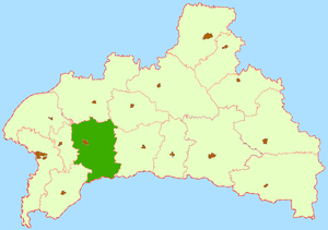
Kobrin district
| Kobrin district | |
|---|---|
| Basic data | |
| Center: | Kobryn |
| Surface: | 2013 km² (rank) |
| Residents: | 88373 ([[]]) (rank) |
| Population density : | Inhabitants / km² (rank) |
| Website: | Kobrin district |
| map | |
The Kobryn Raion ( Belarusian Кобрынскі раён , Russian Кобринский район ) is an administrative unit in the Breszkaya Woblasz in Belarus with the administrative center in the city of Kobryn . The district includes the city of Kobrin and 162 smaller towns. The total area of the administrative unit is 2013 km², the population is approx. 91,000 inhabitants (85.3% Belarusians, 8.1% Russians, 6.3% Ukrainians).
geography
The Kobrin district is located in the southwest of the Breszkaja Woblasz. The neighboring rayons in the Breszkaja Woblasz are in the north Pruschany , in the northeast Bjarosa , in the east Drahitschyn , in the southwest Malaryta , in the west Shabinka and in the northwest Kamyanets .
Eighteen large and small rivers flow through Kobrin district, the total length of which is 298 km. The largest rivers are Mukhavets , Kobrynka (12 km). The largest lakes are Lake Ljuban and Lake Bamauskaje .
Administrative structure
Kobrin Rajon is divided into 13 Selsawjets.
- Selsavet Aniskavichy
- Zelsavet Astromichy
- Selsavet Battschy
- Selsavet Buchavichy
- Selsavet Chidry
- Selsavet Dzivin
- Selsavet Haradsez
- Selsawet Kisjaljoutzy
- Selsavet Navasjolki
- Selsavet Pawizze
- Selsawet Salesse
- Selsavet Teuli
- Selsavet Vosautzy
Web links
- City and district of Kobrin
- Official website of the city and district of Kobrin
- Map of the Kobrin district
Coordinates: 52 ° 13 ' N , 24 ° 22' E

