Rangenbergle
| Rangenbergle | ||
|---|---|---|
|
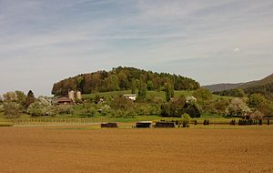
The Rangenbergle near Eningen under Achalm |
||
| height | 588.9 m above sea level NHN | |
| location | Baden-Wuerttemberg , Germany | |
| Mountains | Swabian Alb | |
| Coordinates | 48 ° 30 '2 " N , 9 ° 15' 52" E | |
|
|
||
| rock | Basalt tuff | |
| Age of the rock | approx. 16 million years | |
The Rangenbergle , also popularly called Hexenbergle , is 588.9 m above sea level. NHN high mountain near the municipality of Eningen unter Achalm and belongs to the Swabian Alb .
When plate shifts occurred 17 to 16 million years ago in today's foreland of the Swabian Alb , the Rangenberg was created together with the Swabian volcano . Magma penetrated the surface of the earth and slowly solidified into basalt tuff . This volcanic cone was later exposed by erosion .
Due to the volcanic soil the area around the Rangenberg is very fertile, so this was already in the 16th century for the wine used. The slopes of the mountain are mainly used for agricultural purposes today.

