Rannapungerja (river)
|
Rannapungerja Rannapungerja jõgi |
||
|
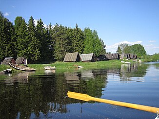
Shortly before it flows into Lake Peipus |
||
| Data | ||
| location | Estonia | |
| River system | Narva | |
| Drain over | Narva → Baltic Sea | |
| source | at the village of Atsalama 59 ° 14 ′ 19 ″ N , 27 ° 21 ′ 28 ″ E |
|
| muzzle | near Rannapungerja in Lake Peipus Coordinates: 58 ° 58 ′ 46 ″ N , 27 ° 10 ′ 41 ″ E 58 ° 58 ′ 46 ″ N , 27 ° 10 ′ 41 ″ E
|
|
| length | 52 km | |
| Catchment area | 601 km² | |
| Left tributaries | Iisaku oja | |
| Right tributaries | Mäetaguse jõgi , Tagajõgi , Tudulinna oja, Milloja | |
| Small towns | Lemmaku , Rannapungerja | |
|
Boathouses near the village of Rannapungerja |
||
|
Rannapungerja lighthouse near the small town harbor |
||
|
Dilapidated wooden bridge near Lemmaku |
||
The Rannapungerja River ( Estonian Rannapungerja jõgi ) flows in northeast Estonia .
description
The Rannapungerja River is 52 kilometers long. Its catchment area covers 601 km². Its discharge rate is 4.9 m³ / s.
The river has its source near the village of Atsalama in the rural parish of Mäetaguse . It flows into Lake Peipus ( Peipsi järv ) near the village of Rannapungerja .
Other names of the river are Roostojana jõgi (on the middle course) and Pungerja jõgi (on the lower course).
Web links
Commons : Rannapungerja - collection of images, videos and audio files


