Ras Ibn Hani
Coordinates: 35 ° 35 ′ 18.4 " N , 35 ° 44 ′ 6.8" E
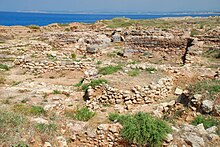
Ras Ibn Hani ( Arabic رأس ابن هاني, DMG Raʾs Ibn Hānī ) was a late Bronze Age city on the Mediterranean coast of Syria with a second residence of the Ugarit royal family . The ruins of the fortified city from the 13th to the end of the 12th century BC Were rediscovered in 1975 nine kilometers north of Latakia and partially exposed.
location
Ras Ibn Hani is located in the middle of a 1.5 kilometer long, narrow peninsula, five kilometers southwest of Ugarit, the capital of the ancient kingdom, whose settlement hill is named after the nearby village of Ras Shamra Tell Ras Shamra ("Fennel Hill"). It belonged to the city of Ugarit and the associated port Minet el-Beida ("white port"), two kilometers west of the capital, to the three central places of the kingdom. Over three quarters of the population lived outside these cities in 150 to 200 small settlements.
From the center of Latakia, the excavation site is 8 kilometers north on the coastal road to the beginning of the Ibn Hani peninsula and another kilometer to the west. Several luxury hotels are lined up along the sandy beach known as the "Cote d'Azur" on the south side of the headland. During the construction of one of these hotels in 1974, late Bronze Age graves were accidentally found adjacent to the hotel property in a tell that was up to nine meters high above sea level . The archaeological area extends to the north coast of the peninsula, which is only about 200 meters wide at this point. It is unclear whether and how much the coastline has changed since ancient times.
The coastal strip on which the kingdom was Ugarit was 40 kilometers north of the capital by the holy mountain Zaphon (Arabic Jabal al-Aqra, Turkish Ziyaret Dağı ), seat of the god Baal limited, and from the inland to the east by the Jebel Aansariye separated . In the south, the border with the Kingdom of Šijannu lay on a river halfway between the present day Jabla and Baniyas . The area is favored by nature thanks to a pleasant climate, abundant uphill rains from the Mediterranean, which fall in winter in front of the mountain range, which in summer also keeps the hot winds from inland.
history
The ancient name of Ras Ibn Hani is unknown. Has been proposed Appu ( "nose"), Biruti ( "wells") or Rašu ( "main"). Middle of the 14th century BC A golden age began for Ugarit after stable borders had been achieved through treaties with the Egyptians . During this phase of expansion, a second residence for the king, such as the summer palace (south palace), and a residence for Aḫat-milki , the mother of King Ammistamru II. (North palace), were built. Another function of the place was to control the sea access for the port of Minet el-Beida.
According to the archaeological findings, Ras Ibn Hani is a new complex from the middle of the 13th century BC. Only a very small part of the residential area has been excavated. It is therefore unclear how many residents lived in the city. It was probably significantly fewer than the 6,000 to 8,000 inhabitants who, according to estimates, lived in the 13th century BC. Lived in the capital Ugarit. End of the 14th century BC Ugarit came into the Hittite sphere of influence as a vassal , which benefited economic development. Niqmaddu II was able to expand the territory within this dependency at the expense of the former anti-Hittite neighbors. The place was abandoned before the so-called sea peoples destroyed all of Ugarit at the beginning of the 12th century. Presumably there was a new settlement shortly afterwards, which u. a. The found imported or imitated Mycenaean pottery of the SH IIIC stage , which is missing in Ugarit and dates back to 1190 BC. Is dated.
Because of the prominent location of the peninsula, during the Hellenistic period from the middle of the 3rd century BC A new settlement took place. Coin finds show that Ras Ibn Hani has been under the control of the Ptolemies since the Third Syrian War . A one kilometer long paved road, a monumental gate and parts of an enclosing wall around the city are proven from this time. The Seleucid King Antiochus IX. (ruled 116–96) had a small fortification built in the southeast corner. After a certain heyday in the 2nd century BC The importance dwindled. During the first three centuries AD, the city was practically uninhabited, there were probably some buildings on the western tip of the peninsula, the location of which can no longer be explored, as the area was built over in the meantime. Building remains, pot fragments and coin finds indicate settlement in the early Byzantine period from the 4th to the 6th century.
After a grave was accidentally found in 1974, excavations began in 1975 in a Syrian-French collaboration led by Adnan Bounni and Jacques Lagarce. First, the south palace was uncovered, followed by the excavation of early Byzantine remains on the top of the hill and in the east of the fortification wall from the Hellenistic period until 1981.
Cityscape
With a total of over 7000 square meters, the palace area was larger than that of Ugarit. Of this, over 5000 square meters were allocated to the south palace, which had a courtyard in the middle and a glacis on the east side , a small part of which has been exposed, and in this a postern ( exit gate ) similar to that of Ugarit. It could have been the king's summer residence. The palace lay on an artificial terrace from which the sea could be seen and signals could be sent to Ugarit. In the east of the South Palace, simple residential buildings from the 13th to 10th centuries were excavated.
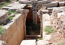
The cuneiform archive was housed in the eastern area of the north palace, which lies directly on the sea . The archive contained over 120 ritual texts, letters and economic texts in a public and a private section. As in Ugarit, Mint el-Beida and Tell Sukas , 35 kilometers south of the coast, the long alphabet of the Ugaritic script with 30 characters, the usual script mainly used within the empire , was found here . It corresponds to the earliest alphabet font discovered for the first time in 1929 in the Ugarit West Archives. The North Palace is considered the Queen Mother's residence; it has been completely excavated and the foundation walls have been partially restored. In its center was a large, paved courtyard, to the east, the archaeologists cleared a tomb ( hypogeum ) made of carefully assembled limestone blocks. The upper stones of the collapsed, pointed cantilever vault were put down a few meters away. The stone steps and walls of the dromos that led down to the tomb have been preserved. The grave, which was looted in antiquity, still contained some pottery that shows trade relations with eastern Mediterranean countries and jewelry items from local production.
Probably soon after the death of the Queen Mother Aḫatmilku, the palace was demoted to a metalworking workshop. Among others, a kalksteinerne mold was discovered, with the artisan oxhide ingot cast from molten copper. Although there are no easily accessible copper deposits in the vicinity of Ras Ibn Hani, copper droplets were discovered in the casting mold, the copper of which, according to analyzes, came from the Cypriot deposit cities of Apliki . It is still doubtful that raw copper was brought from Cyprus to Ras Ibn Hani and that oxhide ingots were cast from it on a large scale here, since limestone is not particularly suitable for casting molds and no furnaces have been discovered nearby. In neighboring workshops, chalcedony was cut into pearls and animal bones into household items.
Of the 3.5 hectare urban area during the Ugaritic rule, 0.5 hectares have been explored so far, mainly in the higher western area. The greater extent in the Hellenistic period in the deeper, flat and sandy area further east has not yet been investigated except for part of the fortification walls. The area is fenced in along the road and is guarded.
literature
- Izak Cornelius, Herbert Niehr: Gods and Cults in Ugarit. Culture and religion of a northern Syrian royal city in the Late Bronze Age. Verlag Philipp von Zabern, Mainz 2004, ISBN 3-8053-3281-5
- Adnan Bounni, Elisabeth and Jacques Lagarce: Ras Ibn Hani I, le Palais Nord du Bronze Recent; Fouilles 1979-1995, Synthesis Preliminaire. Bibliothèque Archéologique et Historique, 151, Institut français d'Archéologie, Beirut 1998
Web links
- Syria - Ras Ibn Hani. France Diplomatique ( Memento of October 15, 2008 in the Internet Archive )
Individual evidence
- ↑ Cornelius / Niehr, p. 24
- ↑ Cornelius / Niehr, p. 13
- ↑ Jacques-Claude Courtois: Enkomi and Ras Shamra, two outposts of the Mycenaean culture. In: Hans-Günter Buchholz (Ed.): Aegean Bronze Age . Wissenschaftliche Buchgesellschaft, Darmstadt 1987, p. 214. ISBN 3-534-07028-3
- ↑ On this problem: Serena Sabatini: Revisiting Late Bronze Age oxhide ingots. Meanings, questions and perspectives. In: Ole Christian Aslaksen (Ed.): Local and global perspectives on mobility in the Eastern Mediterranaean (= Papers and Monographs from the Norwegian Institute at Athens, Volume 5). The Norwegian Institute at Athens, Athens 2016, p. 31 (with further literature)


