Refuge Entre-Deux-Eaux
| Refuge Entre-Deux-Eaux | ||
|---|---|---|
|
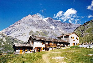
View of the Refuge Entre-Deux-Eaux hut with a view of the Grande Casse mountain . |
||
| location | Department of Savoie ; Auvergne-Rhône-Alpes , France ; Valley location: Termignon | |
| Mountain range | Vanoise massif | |
| Geographical location: | 45 ° 22 ′ 0 ″ N , 6 ° 50 ′ 21 ″ E | |
| Altitude | 2120 m | |
|
|
||
| owner | Private | |
| Construction type | Refuge | |
| Usual opening times | Early June to late September | |
| accommodation | 38 beds, 0 camps | |
The Refuge Entre-Deux-Eaux is a refuge located in the Savoie department in the Auvergne-Rhône-Alpes region . The refuge, located at an altitude of 2120 m, is in the territory of the municipality of Termignon and is within the Vanoise National Park .
geography
The name Entre-deux-Eaux (translated: between two watercourses) refers to the geographic situation on site. The hut is located between the two mountain streams Leisse and Torrent de Rocheure, which flow together approx. 600 m further and form the stream Doron de Termignon . The refuge is located near the south side of the Grande Casse mountain , the highest peak in the Vanoise massif.
description
The refuge offers a maximum of 38 hikers overnight accommodation in a total of 3 bedrooms. The hut is managed in summer from the beginning of June to the end of September. It is a stage destination on the long-distance hiking trails GR 5 and GR 55.
Approaches
The normal route begins at the Bellecombe car park, accessible via the D126 department road, at an altitude of 2307 m. The car park can be reached by public transport. From the parking lot you can reach the hut after about 1h45 on a drivable path.
Alternatively, you can reach the hut from the Fontanettes car park at an altitude of 1620 m (near Pralognan-la-Vanoise ). The ascent takes about 3h30.
Tour possibilities
Transfer to the refuge du Plan du Lac (walking time 1h15), Refuge de la Leisse (2h30), Refuge de la Femma (2h00) and Refuge du Col de la Vanoise (2h00)
Individual evidence
- ↑ Savoie-Mont Blanc ... à pied , Topo-guides FFRandonnée D743, 1st edition. 2016, French
Web links
- Hut website
- Refuge Entre Deux Eaux. In: refuges.info. (French).
- Refuge Entre Deux Eaux. In: outdooractive.com. (French).

