Refuge du Plan du Lac
| Refuge du Plan du Lac | ||
|---|---|---|
|
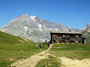
The refuge and the Grande Casse summit |
||
| location | Department of Savoie ; Auvergne-Rhône-Alpes , France | |
| Mountain range | Vanoise massif | |
| Geographical location: | 45 ° 20 '44.2 " N , 6 ° 50' 15" E | |
| Altitude | 2385 m | |
|
|
||
| owner | Private | |
| Built | Renovation in 1974 | |
| Construction type | Refuge | |
| accommodation | 42 beds, 0 camps | |
| Winter room | 20 bearings | |
The Refuge du Plan du Lac is a refuge located in the Savoie department in the Auvergne-Rhône-Alpes region . The privately operated refuge, located at an altitude of 2385 m, is located in the area of the Vanoise National Park .
history
The building of the refuge was built in 1974.
description
The refuge offers 42 hikers a place to sleep when it is open. Outside of this time, 20 stores are available.
Access
The normal route begins at the Bellecombe car park, accessible via the D126 department road, at an altitude of 2307 m. The car park can be reached by public transport. From the parking lot you can reach the hut after about 45 minutes on a drivable path.
Ascents
For the ascent and descent to the Pointe de Lanserlia (2909 m) you should allow 5 hours. On the ascent, you have to overcome a difference in altitude of 535 m.
Transitions
- The easy circular route Balade du Lac Blanc offers beautiful views of the Vanoise glaciers. You should allow 3 to 4 hours for the path, which is 150 meters in altitude
- Transition to the Refuge de l'Arpont (5 hours, difference in altitude 310 m): the path leads over the GR 5 long-distance hiking trail
- Transition to Refuge de la Femma (3 hours, almost flat): can also be planned as a circular route.
- Transition to Refuge de la Leisse (3h30, difference in altitude 310 m): The path leads through the original Leisse valley. After about 1 hour to get to the refuge Refuge Entre-Deux-Eaux past
- Transition to the Refuge du Col de la Vanoise (3h30, difference in altitude 500 m): beautiful path that rewards at the end with a view of the Grand Casse glacier.
particularities
The refuge is only a few hundred meters from the confluence of the Torrent de la Rocheure and Leisse streams . From this point of confluence, the resulting brook is called Doron de Termignon .
Web links
- Internet presence of the refuge
- Refuge du Plan du Lac. In: refuges.info. (French).
- Refuge du Plan du Lac. In: outdooractive.com. (French).
- Refuge du Plan du Lac. In: skitour.fr. (French).

