Renko
Renko [ rɛŋkɔ ] ( Swed. Rengo ) is a former municipality in the southern Finnish landscape Kanta-Häme . At the beginning of 2009 it was incorporated into the town of Hämeenlinna together with the communities of Hauho , Kalvola , Lammi and Tuulos .
Renko is located around 15 km southwest of the city center of Hämeenlinna. In addition to the community center of the same name, the former community area of Renko includes the villages of Ahoinen, Asemi, Kaloinen, Kuittila, Lietsa, Muurila, Nevilä, Oinaala, Uusikylä, Vaimare, Vehmainen and Nummenkylä. The municipality had an area of 290.85 km² (of which 12.32 km² inland water). The last population was 2,365.
Renko is located on the Ochsenweg , the historic trade route from Turku to Häme. Today the Ochsenweg is a tourist route.
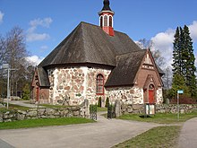
church
The medieval stone church stands out due to its unusual octagonal shape. It was built in the 16th century, but soon fell into disrepair and was no longer used from the middle of the 17th century. In 1783 it was completely renewed, with only the foundation walls remaining from the old church.
Web links
Individual evidence
- ↑ As of 2008, source: Maanmittauslaitos (Finnish land surveying office) (PDF; 247 kB)
- ↑ As of December 31, 2008. Source: Väestörekisterikeskus (Finnish population register). ( Memento of the original from September 20, 2014 in the Internet Archive ) Info: The archive link was inserted automatically and has not yet been checked. Please check the original and archive link according to the instructions and then remove this notice.
Coordinates: 60 ° 54 ' N , 24 ° 17' E

