
Rhine Camino
| Rhine Camino | |
|---|---|
| Data | |
| length | 53 km |
| location | Rhineland-Palatinate |
| Markers |
 |
| Starting point |
Oberlahnstein , Hospital Chapel 50 ° 17 ′ 58.7 ″ N , 7 ° 36 ′ 19.9 ″ E |
| Target point |
Kaub 50 ° 5 '17.4 " N , 7 ° 45' 44.6" O |
| Type | Long-distance hiking trail |
| The highest point | 364 m |
| Lowest point | 63 m |
| Level of difficulty | medium |
| season | Spring to autumn |
The Rhine-Camino ( camino: Spanish = way ) is a section in the network of the Way of St. James in Germany and is considered a continuation of the Lahn-Camino towards the south. It leads from the St. Jakobus Hospital Chapel in Oberlahnstein on the right bank of the Rhine in the Upper Middle Rhine Valley UNESCO World Heritage Site to Kaub . From there you can take the car ferry to cross the Rhine and continue your pilgrimage in Bacharach on the Jakobsweg on the left bank of the Rhine to Bingen am Rhein .
history
The historic Roman and trade routes in the Middle Rhine Valley were already heavily used by pilgrims to Aachen and Cologne as well as by pilgrims to St. James and Rome in the Middle Ages . Churches, monasteries, hostels and hospitals were built along these paths. All that remains of the former hospital in Oberlahnstein is the St. Jakobus chapel, in which a medieval grave of a pilgrim of St. James was found during renovation work (1985–1989). From the meeting point in Lahnstein, the pilgrims could reach destinations such as Cologne, Aachen or Trier and had access to the Way of St. James through France to Santiago de Compostela .
course
The Rhine Camino was first marked in 2001 over a length of around 53 km (including Osterspai even 59 km) between Oberlahnstein and Kaub by the Taunus Club with numerous signs and stickers with the stylized yellow scallop shell on a blue background. The converging ribs of the shell show the direction as an arrow. In the meantime, the Middle Rhine regional group of the St. Jakobus Society Rhineland-Palatinate-Saarland eV has taken on responsibility for maintaining the marking.
| Suggested stages | Stage length | Places in order of reaching |
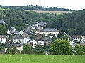
| Stage 1 | approx. 18 km | Oberlahnstein - Braubach - Osterspai |
| Stage 2 | approx. 22 km | Osterspai - Kamp-Bornhofen - Lykerhausen - ( Dahlheim ) - Prath - Wellmich |
| Stage 3 | approx. 19 km | Wellmich - St. Goarshausen - Patersberg - Bornich - Dörscheid - Kaub |
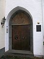
Portal of the hospital chapel, Oberlahnstein

Marksburg, Braubach

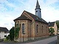
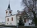
St. Martin, Osterspai

Jakobus Chapel, Osterspai
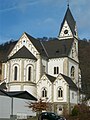
St. Nikolaus, Kamp-Bornhofen
Evangelical Church, Lykershausen
St. Jakobus, Dahlheim

Wellme

St. John the Baptist, St. Goarshausen

Evangelical Church, Patersberg

Evangelical Church, Bornich
Evangelical Church, Dörscheid

Chew


James traces
In the course of the Rhine Camino there are some historical as well as modern traces of St. James. In addition to the Jakobus Chapel in Oberlahnstein, traces of the Jakobus cult can also be found in other places along the way. For example, the municipality of Dahlheim has the scallop shell in its coat of arms.
| Oberlahnstein, St. Jakobus Hospital Chapel | James statue and symbols in the |
| Dahlheim | Scallop in the municipal coat of arms |
| Dahlheim, parish church St. Jakobus | James statue |
| Osterspai, parish church of St. Martin | James statue |
| Osterspai, St. Jakobus Chapel | James statue |
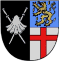
Municipal coat of arms, Dahlheim

James statue, Dahlheim
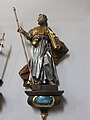
James statue in St. Martin, Osterspai

James statue, Osterspai


Pilgrim stamp

In almost every stage there is the possibility of getting a pilgrim stamp for your pilgrim ID ( Spanish = credencial ).
Hiking maps
- Upper Middle Rhine Valley - Loreley-Boppard (1: 25,000) . 4th edition. LVermGeo Rheinland-Pfalz, Koblenz 2011, ISBN 978-3-89637-364-9 .
- Upper Middle Rhine Valley - Rüdesheim-Bingen (1: 25,000) . 4th edition. LVermGeo Rheinland-Pfalz, Koblenz 2011, ISBN 978-3-89637-365-6 .
- RheinWandern Nord (1: 25,000) . 1st edition. LVermGeo Rheinland-Pfalz, Koblenz 2011, ISBN 978-3-89637-388-5 .
- RheinWandern Süd (1: 25,000) . 1st edition. LVermGeo Rheinland-Pfalz, Koblenz 2011, ISBN 978-3-89637-387-8 .
Web links
- Rhine Camino
- GPS data
Individual evidence
- ↑ Michael Hans Peter Eisenbarth: St. Jakobus Hospital Chapel in Lahnstein / Rhine . 1st edition. Imprimatur Verlag, Lahnstein 2010, ISBN 978-3-9813195-2-1 .
- ^ Pilgrim stamp Rhein-Camino. Retrieved December 3, 2013 .