
Jakobsweg on the left bank of the Rhine
| Jakobsweg on the left bank of the Rhine | |
|---|---|
| Data | |
| length | 240 km |
| location | North Rhine-Westphalia / Rhineland-Palatinate |
| Markers | Stylized yellow scallop shell on a blue background |
| Starting point |
Cologne , Dom 50 ° 56 ′ 26.9 ″ N , 6 ° 57 ′ 29.6 ″ E |
| Target point |
Bingen am Rhein , Klopp Castle 49 ° 57 ′ 57.4 ″ N , 7 ° 53 ′ 47.7 ″ E |
| Type | Long-distance hiking trail |
| The highest point | 469 m |
| Lowest point | 39 m |
| Level of difficulty | easy to medium |
| season | Spring to autumn |

The links Rheinische St. James is a section of the network of paths of pilgrims in Germany. It was inaugurated on April 14, 2013 and leads from Cologne via Bonn and Koblenz through the UNESCO World Heritage Upper Middle Rhine Valley to Bingen am Rhein . From there you can continue your pilgrimage via the Rheinhessen Jakobsweg to Worms or the Hunsrücker Jakobsweg to Trier .
history
To revive the old Way of St. James between Cologne and Bingen, a working group was founded in March 2009 in the Arnstein an der Lahn monastery . The historic Roman and trade routes in the Middle Rhine Valley were already heavily used by pilgrims to Aachen and Cologne as well as by pilgrims to St. James and Rome in the Middle Ages . With the opening of the Jakobsweg on the left bank of the Rhine in April 2013, a long-standing gap in the German Jakobsweg network was closed. Pilgrims now have the opportunity to connect to other ways to get to Santiago de Compostela to the tomb of the apostle Jakobus the Elder. to make a pilgrimage.
The Jakobsweg on the left bank of the Rhine was primarily laid out for pilgrims on foot and runs on the section from Rolandsbogen to Bingen mainly on the Rheinburgenweg . However, there are also alternatives by bike and boat on this delightful section. The connection to the public transport network is excellent, so that even individual stages can be completed by day pilgrims. From Koblenz, the St. James Way on the left bank of the Rhine leads through the UNESCO World Heritage Upper Middle Rhine Valley. The sacred landscape with u. a. the Cologne Cathedral , the Bonn Minster , the St. Kastor Basilica in Koblenz, the Church of Our Lady in Oberwesel or the St. Martin Basilica in Bingen are essential contact points for pilgrims.
Markers

The marking work was carried out in 2012 in North Rhine-Westphalia by the Eifelverein and in Rhineland-Palatinate by the Central Rhine regional group of the St. Jakobus-Gesellschaft Rheinland-Pfalz-Saarland eV so that the route can be completed without additional map material. The symbol of the stylized yellow scallop on a blue background, which is now valid throughout Europe, was used in the form of stickers, aluminum signs and spray markings with forest paint. The converging ribs of the scallop show the pilgrim the direction of the path.
course
The St. James Way on the left bank of the Rhine was realized by the Middle Rhine regional group of the St. Jakobus Society Rhineland-Palatinate-Saarland eV and marked over a length of around 240 km between Cologne and Bingen. In the Stolzenfels area , a short section is used together with the Moselle Camino (Jakobsweg from Stolzenfels to Trier).
| Suggested stages | Stage length | Places in order of reaching |
|---|---|---|
| Stage 1 | approx. 18 km | Cologne - Rodenkirchen - Sürth - Godorf - Wesseling |
| Stage 2 | approx. 16 km | Wesseling - Widdig - Uedorf - Hersel - Graurheindorf - Bonn |
| Stage 3 | approx. 20 km | Bonn - Bad Godesberg - Heiderhof - Ließem - Niederbachem |
| Stage 4 | approx. 23 km | Niederbachem - Rolandsbogen - Rolandseck - Oberwinter - Bandorf - Unkelbach - Remagen - Bad Bodendorf - Sinzig |
| Stage 5 | approx. 24 km | Sinzig - Oberbreisig - Bad Breisig - Brohl-Lützing - Namedy - Andernach |
| Stage 6 | approx. 28 km | Andernach - Miesenheim - ( Weißenthurm ) - Kettig - Mülheim-Kärlich - Rübenach - Güls - Koblenz |
| Stage 7 | approx. 18 km | Koblenz - (Stolzenfels) - Rhens |
| Stage 8 | approx. 16 km | Rhens - Brey - Boppard - Bad Salzig |
| Stage 9 | approx. 26 km | Bad Salzig - Weiler - Hirzenach - Holzfeld - St. Goar - Urbar - Oberwesel |
| Stage 10 | approx. 14 km | Oberwesel - Bacharach |
| Stage 11 | approx. 19 km | Bacharach - Neurath - Medenscheid - Oberdiebach - Niederheimbach - ( Trechtingshausen ) - Gerhardshof |
| Stage 12 | approx. 12 km | Gerhardshof - Bingen |

Cologne Cathedral seen from Roncalliplatz

Bonn Minster taken from the cloister
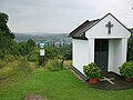
Heiligenhäuschen near Niederbachem
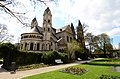
Basilica of St. Castor Koblenz

Saint Goar statue at Rheinfels Castle

View of the Loreley

St. Martin's Basilica, Bingen


.JPG)

.JPG)


James traces
In the course of the pilgrimage there are several opportunities to look at the representations of St. James.
| place | description |
|---|---|
| Cologne Cathedral | Statue at the Petrusportal (around 1380) Wooden figure (19th century) on the Claren altar in the north aisle Jakobus window (around 1330) and painting on the Crucifixion altar in the Maternuskapelle (former Jakobuskapelle) in the high choir (only accessible with a guide) Seated figure at the Epiphany Shrine (1190-1220) , Marble figure on the high altar front (around 1310), choir pillar figure (around 1275), floor mosaic with Cathedral of Santiago (1892) |
| Cologne, Basilica of St. Maria in the Capitol | Window in the north aisle (1989) Window in the south aisle (16th century) |
| Cologne, St. Georg Basilica | Window in the west building (1930) |
| Bonn, senior citizens' residence St. Agidius and St. Jakobus | Gable and statue of St. James of the former pilgrims' hospital (17th century) in the inner courtyard facade (Breite Straße) |
| Remagen, parish church of St. Peter and Paul | Fresco in today's baptistery (12th century) |
| Oberbreisig, parish church of St. Viktor | Depiction of a pilgrim coronation on the south wall of the aisle (14th century) |
| Bad Breisig, St. Marien parish church | Representation of James on the antependium of the right side altar |
| Andernach, St. Josef Hospital Chapel | Fresco on the east wall |
| Koblenz, St. Castor's Basilica | late Gothic panel on the south wall (around 1840) |
| Koblenz, Jakobus Chapel | former cemetery chapel of the German Order (1355) |
| Rhens, old church of St. Dionysius | Statue on the high altar (18th century) |
| Jakobsberger Hof, Jakobus Chapel | James statue in the former monastery chapel |
| Boppard, Jakobsberg | St. James Chapel (1892) |
| St. Goar, collegiate church | Fresco above an arch gusset in the nave (south side) |
| Oberwesel, Church of Our Lady | Fresco from the figure on the right column in front of the rood screen (16th century) in the mercy seat under a window on the south wall (15th century) |

Statue at the Petersportal, Dom, Cologne

Window picture, St. Georg, Cologne

Coronation of pilgrims, St. Viktor, Bad Breisig

Panel painting Jakobus d. Ä., St. Kastor, Koblenz

James statue, St. Dionysius, Rhens

Fresco, Liebfrauenkirche, Oberwesel


Species protection

On numerous sections of the European Way of St. James, a start has already been made to combine path markings with species protection in order to maintain a broad biodiversity (species diversity). Bird nesting boxes, bat boxes and insect and wild bee hotels with yellow arrows and scallop symbols have also been hung and set up on the St. James Way on the left bank of the Rhine.
Hiking maps
The Way of St. James on the left bank of the Rhine is not yet shown in most hiking maps. This will probably only be the case in the future with new editions. Instead, you can make do with maps of the Rheinburgenweg.
Maps showing the Way of St. James on the left bank of the Rhine
- Soonwald-Nahe Nature Park, sheet 3 (1: 25,000) . 2nd Edition. LVermGeo Rheinland-Pfalz, Koblenz 2012, ISBN 978-3-89637-374-8 .
Maps with Rheinburgenweg
- RheinWandern Nord (1: 25,000) . 1st edition. LVermGeo Rheinland-Pfalz, Koblenz 2011, ISBN 978-3-89637-388-5 .
- RheinWandern Süd (1: 25,000) . 1st edition. LVermGeo Rheinland-Pfalz, Koblenz 2011, ISBN 978-3-89637-387-8 .
literature
- Franz Blaeser, Michael Kaiser, Hans Ries, Wolfgang Scholz: St. James Way on the left bank of the Rhine from Cologne to Bingen . 1st edition. Conrad Stein Verlag, Welver / Westf. 2014, ISBN 978-3-86686-464-1 .
Web links
- St. James Way on the left bank of the Rhine opened.
- Koblenz is again the Jakobsweg station.
- Revitalization of the St. James Way on the left bank of the Rhine. (No longer available online.) Archived from the original .
- The Way of St. James closes the gap in the Middle Rhine Valley.
- A very special ornament for the Rübenach Way of St. James.
- Jakobsweg on the left bank of the Rhine leads back via Oberbreisig. (No longer available online.) Archived from the original .
- 1st stage on the St. James Way on the left bank of the Rhine.
Jakobsweg on the left bank of the Rhine
- Website Linksrheinischer Jakobsweg
- Project website St. Jakobus-Gesellschaft Rheinland-Pfalz-Saarland eV
GPS data
Individual evidence
- ↑ Species protection and path marking. Retrieved December 3, 2013 .