
Eifel Camino
| Eifel Camino | |
|---|---|
 Destination of the Eifel-Camino in Trier: Benedictine Abbey St. Matthias |
|
| Data | |
| length | 158 km |
| location | Rhineland-Palatinate |
| Markers |
 |
| Starting point |
Andernach-Namedy 50 ° 28 ′ 29 ″ N , 7 ° 20 ′ 33.6 ″ E |
| Target point |
Trier , Benedictine Abbey of St. Matthias 49 ° 44 ′ 16.8 ″ N , 6 ° 37 ′ 53.1 ″ E |
| Type | Long-distance hiking trail |
| The highest point | 512 m |
| Lowest point | 57 m |
| Level of difficulty | medium |
| season | Spring to autumn |
The Eifel-Camino ( camino: Spanish = way ) is a section in the network of the Way of St. James in Germany. It leads from Andernach-Namedy through the romantic Eifel to the Benedictine Abbey of St. Matthias in Trier . From there you can continue your pilgrimage via Schengen to Vézelay , the starting point of the Via Lemovicensis .
history
As early as the late Middle Ages , Christians made pilgrimages to the grave of the apostle Matthias in Trier or made a stopover on their way to Santiago de Compostela . An important pilgrimage route led from Andernach am Rhein to Trier an der Mosel via a former Roman road . The St. Matthias Brotherhood of Mayen has set itself the task of marking the routes of the St. James pilgrims in the Mayen-Koblenz district , starting in 2008 . Later other districts were included, so that today the entire Eifel Camino as far as Trier is provided with signposts.
course
The main route of the Eifel Camino is around 160 kilometers. The path begins at the border between the Mayen-Koblenz district and the Ahrweiler district in the fishing village of Fornich, which no longer exists, and is signposted from the Namedy Schützenplatz over the Eifel heights to Trier.
From Namedy to Miesenheim there is a common route with the St. James Way on the left bank of the Rhine . In Klausen the Eifel Camino meets the Mosel Camino and shortly before Biewer the Via Colonensis joins it coming from Cologne . All three Way of St. James lead the pilgrims to their common goal in Trier.
In addition, there are three feeder routes from Nickenich , Lonnig and Münstermaifeld , all of which join the main route in Mayen . There is also a variant of the route from Kruft in the direction of Maria Laach Abbey , a cross connection in Mendig, and from Plaidt a loop to the baroque church of St. Cäcilia in Saffig .
| Suggested stages | Stage length | Places in order of reaching |
| Main way | ||
| Stage 1 | approx. 19 km | Namedy - Andernach - Miesenheim - Plaidt - (Saffig) - Kretz - Kruft |
| Stage 2 | approx. 15 km | Kruft - Fraukirch - Mayen |
| Stage 3 | approx. 19 km | Mayen - Geisbüschhof - Monreal - Heunenhof - Urmersbach - Kaisersesch |
| Stage 4 | approx. 20 km | Kaisersesch - Maria Martental - Alflen - Gillenbeuren - Driesch - Lutzerath |
| Stage 5 | approx. 29 km | Lutzerath - Kenfus - Bad Bertrich - Hontheim - Wispelt - Bausendorf - Neuerburg - Dorf - Wittlich |
| Stage 6 | approx. 20 km | Wittlich - Pohlbach - Klausen - Klüsserath |
| Stage 7 | approx. 19 km | Klüsserath - Schweich |
| Stage 8 | approx. 22 km | Schweich - Quint - Ehrang - Biewer - Trier |
| Feeder path from Nickenich to Mayen | ||
| Feeder 1 | approx. 21 km | Maria Laach - Mendig - Kottenheim - Mayen |
| Feeder path from Lonnig to Mayen | ||
| Feeder 2 | approx. 21 km | Lonnig - Minkelfeld - Kerben - Polch - Hausen - Mayen |
| Feeder path from Münstermaifeld to Mayen | ||
| Feeder 3 | approx. 17 km | Münstermaifeld - Mertloch - Polch - Hausen - Mayen |
Andernach, Mariendom

Kruft, St. Dionysius

Mayen, Genovevaburg

Monreal (2009)

Alflen
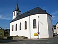
Kennfus, St. Mary

Bad Bertrich
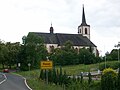
Bausendorf, St. Peter
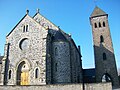
Pilgrimage Church of St. Maria, Klausen

Kluesserath

St. Martin, Schweich

Trier-Ehrang, cross on the Heidestuben

Information board on the Way of St. James at St. Jakobus Church, Trier-Biewer

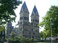
Trier, High Cathedral of St. Peter

Sarcophagus of the Apostle Matthias
.jpg)
.jpg)


.jpg)


.JPG)


James traces
In the course of the Eifel-Camino and its branch lines, some historical as well as modern Jakobus traces or representations can be found.
| place | description |
| Main way | |
| Andernach, St. Josef Hospital Chapel | Fresco on the east wall |
| Klausen, pilgrimage church of St. Maria | Original scallop shell from Santiago de Compostela on the staircase, St. James relief on the confessional |
| Klüsserath, Echternacher Hof | James Altar (1935) |
| Klüsserath, Parish Church of the Rosary Queen | James figure on the high altar (1622) |
| Biewer, Biewerer Strasse | St. Jacob's Fountain (1832) |
| Biewer, parish church of St. James | Statues and window pictures |
| trier | Jakobus statue on the Steipe Jakobus portrait on a column in the Church of Our Lady Distance to Santiago de Compostela at the fountain in the abbey courtyard of St. Matthias Jakobus sculpture at the united hospitals and in the former collegiate church |
| Feeder routes | |
| Niedermendig, parish church of St. Cyriakus | Fresco Coronation of the Pilgrims / Charlemagne |
| Lonnig, parish church St. Jakobus | James statue |
| Lonnig, Jakobus Elementary School | James statue |

Jakobus altar, Klüsserath

St. Jacob's Fountain, Biewer

James statue, Trier

James sculpture, Trier


Special features along the way
With the support of the regional economy and numerous private patrons, pilgrim stones and information steles made of basalt lava were placed along the path in addition to the regular markings. The pilgrim stones are carved with a scallop shell and show pilgrims the right way. The steles were set up in exposed places and provide useful information about them. In September 2011, a five-meter-high Jakobus column with an attached rest area was inaugurated as a special feature of the Eifel-Camino on the “Old Monrealer Weg” between Mayen and Monreal. In 2013, large information boards were set up in some municipalities.

Pilgrim fountain, Maria Laach Abbey

Pilgrim stone

James relief, Mayen
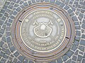
Manhole cover, Mayen

Information stele

Jakobussäule, Old Monreal Way

Pilgrim fountain, Kaisersesch


Pilgrim stamp
In almost every stage there is the possibility of getting a pilgrim stamp for your pilgrim ID ( Spanish = credencial ). Most of the stamps were designed exclusively for the Eifel-Camino and contain the representation of a special feature of the respective location within a uniform basic scheme.
Pilgrim hostels
There are currently three pilgrim hostels along the Eifel-Camino: the Refugio zur Pilgerschnecke in Thür, the pilgrim room in Kaisersesch and the Eberhardsklause in Klausen.
Species protection

On numerous sections of the European Way of St. James, a start has already been made to combine path markings with species protection in order to maintain a broad biodiversity (species diversity). Numerous nesting boxes for birds and bats as well as insect hotels with yellow arrows and scallop symbols have also been hung and set up on the Eifel-Camino .
Hiking maps
The Eifel-Camino with the scallop shell is shown in the following hiking maps:
- Dream paths in the Rhein-Mosel-Eifel-Land (1: 50,000) . 2nd Edition. LVermGeo Rheinland-Pfalz, Koblenz 2010, ISBN 978-3-89637-411-0 .
- Leisure map hiking area Moselle: Maifeld and Untermosel (1: 25,000) . 3. Edition. LVermGeo Rheinland-Pfalz, Koblenz 2011, ISBN 978-3-89637-255-0 .
- Hiking map No. 21: Holiday region of thermal baths and maars (1: 25,000) . Eifelverein, 2010, ISBN 978-3-921805-69-5 .
- Hiking map No. 24: Wittlicher Land (1: 25,000) . 2nd Edition. Eifelverein, 2010, ISBN 978-3-921805-62-6 .
- Leisure map hiking area Moselle: Neumagen-Drohn - Schweich (1: 25,000) . 3. Edition. LVermGeo Rheinland-Pfalz, Koblenz 2009, ISBN 978-3-89637-259-8 .
literature
Wolfgang Scholz, Franz Blaeser, Dieter Preß, Heinz Schäfer: Eifel-Camino from Andernach to Trier . 1st edition. Conrad Stein Verlag, Welver 2016, ISBN 978-3-86686-489-4 .
Web links
- Eifel Camino
- Pilgrim hostels
- GPS data
Individual evidence
- ^ Gertraud and Heinz-Egon Rösch: Roman roads between the Moselle and the Rhine . 1st edition. Mainz 2010, ISBN 978-3-00-029335-1 , p. 58-60 .
- ^ Eifel-Camino pilgrim stamp. Retrieved December 13, 2013 .
- ↑ Species protection and path marking. Retrieved December 13, 2013 .