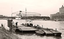
Rhine ferry Altrip – Mannheim
The Rhine ferry Altrip – Mannheim is a ferry that crosses the Rhine at about river kilometer 415.5. It connects the right bank, industrially shaped Mannheim district Neckarau the left bank community Altrip and the recreation area Blaue Adria .
The shareholders of the operating company “Rheinfähre Altrip GmbH” are the city of Mannheim (50 percent), the Rhein-Pfalz-Kreis (30 percent) and the municipality of Altrip (20 percent).
historical development

The Altrip ferry was first mentioned in 1262, when Count Palatine Ludwig II gave the Himmerod Monastery , to which Altrip belonged at the time, the passagium (crossing rights). The Rhine ferry Altrip was thus able to celebrate its 750th anniversary in 2012. In 1891 the first yaw ferry was purchased, which crossed the river by means of a longitudinal rope. In 1896 an attempt was made to operate the ferry with a cross rope. But as early as 1898 the lengthways rope was used again. With the help of the current, the ship was able to cross the Rhine. However, due to the ever increasing shipping traffic, this ferry method prevented a reliable timetable and was replaced in 1958 by a ferry with its own motor.
technology
The ferry currently in use was built in 1991 at the New Germersheim shipyard in Germersheim and has been in service all year round since then. It has a load capacity of 45 tons and is approved for a maximum of 400 passengers. Vehicles up to a single weight of 16 tons are transported, as well as two-wheelers and pedestrians . It also transports the 98 regional bus from Monday to Friday , which connects Altrip and the Friedrichstrasse transport hub in Mannheim-Neckarau at the VRN tariff. Large taxis are used on the bus route.
Transport links
The abandoned Altrip stop on the Rheinbahn from Mannheim Hbf to Karlsruhe Hbf was on the right bank of the Rhine in the Mannheim district just a few meters from the ferry pier. The discussed replacement of the ferry with an expressway, which could connect the federal highway 9 in Rhineland-Palatinate and the Rhein-Neckar-Schnellweg ( B 38a ) to a motorway ring via a bridge or a tunnel , was rejected for financial and ecological considerations and ended in 1998 deleted from the Federal Transport Infrastructure Plan. The route of the B 38a, which was planned in 1967, was withdrawn in 2004 by the Rhineland-Palatinate Ministry of Transport . In the meantime, it is no longer in the planning stage - as confirmed again for the 2015 Federal Transport Infrastructure Plan. On the Mannheim side, an extension of the B 38a leads directly to the ferry. Conversely, the ferry takes you directly to the B 38a, the B 36 and the Rheinauhafen .
business
During rush hour traffic - as well as on roads - there are regular bottlenecks: In the morning, cars jam on the Altriper Ufer and in the evening on the banks of Mannheim-Neckarau. That is why the operating company's board of directors examined the purchase of a larger ferry in 2009. However, it was decided to extend the ferry to accommodate more vehicles. In 2012, the ferry's capacity was increased by extending it by seven meters. It now offers space for a maximum of 21 cars per crossing. Around 685,000 cars and 150,000 bicycles are transported annually.
The ferry is increasingly coming to the end of its operating hours. From around 2020 a new ferry is to be used for around 24 cars per crossing. In connection with a technically improved ship, 40 more individual trips should be possible every day, which would correspond to an increase of 20 percent.
Occasionally the water level of the Rhine also represents a certain imponderability. For example, the ferry traffic had to be stopped for almost one and a half months from mid-October 2018 due to low water, which temporarily fell below the historically low level of 92 cm (September 28, 2003) at the Mannheim gauge .
At the end of August 2019, Hochstrasse Süd ( Bundesstrasse 37 and, further on, Bundesautobahn 650 ) in Ludwigshafen was closed due to structural defects. Meanwhile (as of the end of February 2020) preparations for the demolition are underway. The resulting impairment of road traffic between Mannheim and Ludwigshafen has significantly increased the flow of traffic to the Rhine ferry Altrip-Mannheim to up to 2200 vehicles a day, which are transported every ten minutes. This capacity utilization will not decrease in the medium term: After the necessary new construction of Hochstraße Süd, Hochstraße Nord in Ludwigshafen is due to be partially demolished and converted into a city street.
Individual evidence
- ^ Ministry of Transport and Infrastructure Baden-Württemberg: Hearing on the registration list for the Federal Transport Infrastructure Plan 2015. (PDF 828 KB) No. 3.42 B 38a, new Rhine bridge south of Mannheim / Ludwigshafen. September 13, 2013, p. 45 , accessed November 10, 2018 .
- ↑ Mannheimer Morgen of March 12, 2009, page 28, "Replacement ship after 18 years?"
- ↑ Mannheimer Morgen of March 17, 2012, page 26, "Elegant ride across the river" ( online )
- ↑ Mannheimer Morgen of January 26, 2018, page 25, "New ferry for more passengers"
- ↑ Mannheimer Morgen from October 15, 2018, page 26, low water: compulsory break for ferries
- ↑ Mannheimer Morgen from February 22nd, 2020, page 25, That adds to piecework .
Web links
See also
Coordinates: 49 ° 26 ′ 30 ″ N , 8 ° 30 ′ 5 ″ E


