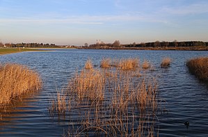
Riemer See
| Riemer See | |
|---|---|

|
|
| The Riemer See 2013 | |
| Geographical location | Munich , Messestadt Riem |
| Places on the shore | Munich |
| Data | |
| Coordinates | 48 ° 7 '34 " N , 11 ° 42' 20" E |
| Altitude above sea level | 530 m above sea level NN |
| surface | 7.7 ha |
| length | 0.70 km |
| width | 0.15 km |
| scope | 1.74 km |
| Maximum depth | 18 m |
| Middle deep | 14 m |
The Riemer See (also known as BUGA-See or bathing lake in the Riemer Park ) is an artificially created bathing lake in the east of Munich as part of the Federal Horticultural Show 2005 .
In the new Munich district Messestadt Riem , the landscape park planned by the French landscape architect Gilles Vexlard , the Riemer Park, was created . The Riemer See is located in the eastern part of this landscape park. It covers a pure water surface of approx. 7.7 hectares and is on average 14 m deep, in a few places up to 18 m. The landscape park that directly surrounds the lake, with the north bank, jetty and beach, measures another 6.1 hectares.
Planning idea
The north bank connects the lake with the emerging new residential quarters and is given an urban character by the quays and the lake promenade. The south bank, which faces away from the development and lies in the transition to the open landscape, is shaped by landscape and is designed with extensive meadows and woody plantings. Species-rich perennials were planted in the narrow shallow water zone and on the embankment. The near-natural west bank with a wide belt of reed beds in a shallow water zone is used for water purification and as an overflow area with an infiltration basin. A footbridge spans the planted shallow water zone. It serves as an important route connection in north-south direction and allows an intense experience of nature. Finally, the east bank is the bathing bank. A lawn for sunbathing adjoins the pebble beach. The bank slopes gently and is also an ideal and safe swimming area for children.
Technical design
A sealed groundwater lake with a high water level was built , in particular because of the very high groundwater fluctuations and the requirement to create shallow bank zones despite the given lack of space . The lake is surrounded by a narrow sealing wall driven into the water-impermeable layers ( tertiary ), thus creating a tight trough. In order to avoid a build-up of the groundwater, three groundwater crossings ( culverts ) were built through which the groundwater is transferred from south to north. In addition, groundwater is removed by pumps outside the narrow sealing wall and discharged into the lake. Excess water flows off via an overflow at the western end of the lake, is cleaned in the infiltration basin and returned to the groundwater. This water exchange ensures a constant quality of the water.
safety
As part of the landscaping for the Federal Garden Show 2005, a new water rescue station was also built between the north and east banks of the Riemer See. For the duration of the Federal Garden Show from April 28 to October 9, 2005, this was operated full-time by the water rescue service of the Bavarian Red Cross as the Munich Riem local group . Since the Federal Horticultural Show closed its doors, the Munich Riem water rescue service has been acting on a voluntary basis, the local group now consists of around 100 members, around 25 of whom are active.
Since the opening of the Federal Horticultural Show in 2005, there have been ten bathing deaths at the lake by July 2015. Planning errors in connection with steep entry passages, missing warning notices and an unfavorable location of the watchtower station, from which life-threatening areas are not visible, were discussed as causes. In the spring of 2017, buoys to mark the steep bank and warning signs were therefore installed.
