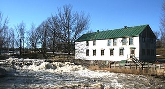
Rivière Bayonne
| Rivière Bayonne | ||
| Data | ||
| location | Lanaudière in Quebec (Canada) | |
| River system | Saint Lawrence River | |
| confluence | several source streams 46 ° 13 ′ 14 ″ N , 73 ° 26 ′ 0 ″ W |
|
| muzzle |
Chenal du Nord ( St. Lawrence River ) Coordinates: 46 ° 5 ′ 21 ″ N , 73 ° 9 ′ 56 ″ W 46 ° 5 ′ 21 ″ N , 73 ° 9 ′ 56 ″ W.
|
|
| length | approx. 50 km | |
| Catchment area | 347 km² | |
| Small towns | Berthierville | |
| Communities | Saint-Félix-de-Valois , Sainte-Élisabeth , Sainte-Geneviève-de-Berthier | |
|
Moulin Emery at Saint-Félix-de-Valois |
||
The Rivière Bayonne is a left tributary of the Saint Lawrence River in the Lanaudière administrative region of the Canadian province of Québec .
River course
The Rivière Bayonne arises at the confluence of several source streams about 10 km south of the town of Saint-Gabriel on Lac Maskinongé at the foot of the Laurentine Mountains . It initially flows south to Saint-Félix-de-Valois and Sainte-Élisabeth . Then he turns to the east. It passes Sainte-Geneviève-de-Berthier . The Rivière Bayonne flows along the northern edge of Berthierville and finally flows into the Chenal du Nord arm of the St. Lawrence River above Lac Saint-Pierre .
The Route 345 follows-Geneviève-de-Berthier Sainte river running between Saint-Félix-de-Valois and.
Naming
The river flows through the former Seigneurie Berthierville . This was transferred to Pierre de Lestage (1682–1743) in 1718 . Its birthplace, Bayonne in southwest France, gave its name to the Rivière Bayonne.
Covered bridges
The covered bridge Pont Grandchamp spans the river in the municipality of Sainte-Geneviève-de-Berthier.

