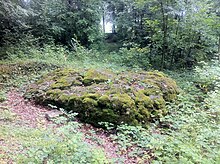
Roderichstein
The Roderichstein is a boulder near Gennersbrunn in the canton of Schaffhausen . It has a diameter of five meters, originally comes from the area of today's Graubünden and was deposited by the glacier near the hamlet of Gennersbrunn in the last Ice Age.
In mid-June 1067, the Roman-German King Heinrich IV awarded the founder of the Allerheiligen monastery and the city of Schaffhausen to Count Eberhard VI. von Nellenburg a large hunting area (Mundat, Wildbann ), which enclosed the Randen area in the north of the Rhine. The designation of the wild ban border began and ended in the document from 1067 with the Roderichstein. The border ran from the Roderichstein to the Rhine, included the entire Rhine and led down the Rhine to Urwerf near Schaffhausen, then led to the Lauferberg - Siblingen - Randen - Buchberg - Orserental - Wirbelberg - Geissberg - Rheinhard - and back to the Roderichstein.
Because the monastery property fell to the city as a result of the Reformation in 1529 and the newly founded canton of Schaffhausen became the legal successor to the city of Schaffhausen in 1803, the hunting area known as Wildbann from 1067 can be seen as the core of today's canton of Schaffhausen.
Over time, the landmark was forgotten and overgrown. In 1947 school inspector Erwin Bührer rediscovered the stone.
Web links
- Erratiker ( Memento from January 15, 2013 in the web archive archive.today )
- Roman Sigg: Mundat (SH). In: Historical Lexicon of Switzerland .
Individual evidence
- ↑ A foundling named Roderich (PDF; 19 kB)
Coordinates: 47 ° 43 '5.5 " N , 8 ° 41' 33.2" E ; CH1903: 694 089 / 286040


