Rodersdorf (Wegeleben)
|
Rodersdorf
City way life
|
|
|---|---|
| Coordinates: 51 ° 52 ′ 41 ″ N , 11 ° 13 ′ 2 ″ E | |
| Height : | 107 m |
| Residents : | 280 (1993) |
| Incorporation : | May 1, 2001 |
| Postal code : | 38828 |
| Area code : | 039423 |
Location of Rodersdorf in Saxony-Anhalt |
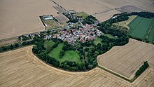
Rodersdorf is a district of the town of Wegeleben in the Harz district in Saxony-Anhalt .
geography
The state road 73 leads through Rodersdorf and the Bode flows around the place. The Selke flows into the Bode southeast of the village .
history
In 978 Rodersdorf in Schwabengau in the county of Ditmars was first mentioned in a document from Emperor Otto II.
The community Rodersdorf belonged to the administrative community Untere Bode and was located in the district of Halberstadt . Rodersdorf lost its political independence when it was incorporated into Wegeleben on May 1, 2001.
coat of arms
The coat of arms was approved on February 5, 1998 by the Magdeburg Regional Council.
Blazon : “Split between gold and green; in front a rising green oak leaf, in the back two golden plowshares, the tips turned downwards. "
The colors of the church are gold (yellow) and green.
The coat of arms colors green and gold result from the old family coat of arms of the last owners of the inn in Rodersdorf. They reflect the rural character of the region. The plowshares contained in the coat of arms are symbolic of the two dominant estates in Rodersdorf over the centuries, one of which was formerly part of the Adersleben monastery and the second was a fiefdom, with changing owners. The oak leaf symbolizes the first planting of the cemetery in the village. The oaks present there were also used as stubborn heads or stamp symbols in earlier times.


