
Rohrer Giessen
| Rohrer Giessen | ||
 Rohrer Giessen |
||
| Data | ||
| Water code | CH : AG570488 | |
| location | Switzerland | |
| River system | Rhine | |
| Drain over | Giessen (Aare) → Aare → Rhine → North Sea | |
| source | west of Rohr AG 47 ° 24 ′ 13 ″ N , 8 ° 4 ′ 15 ″ E |
|
| Source height | 361 m above sea level M. | |
| muzzle | North of Rohr in Giessen Coordinates: 47 ° 24 '32 " N , 8 ° 5' 24" E ; CH1903: 649 158 / 251112 47 ° 24 '32 " N , 8 ° 5' 24" O |
|
| Mouth height | 357 m above sea level M. | |
| Height difference | 4 m | |
| Bottom slope | 2 ‰ | |
| length | 2 km | |
The Rohrer Giessen is a river of 2 kilometers in length in the meadow landscape on the Aare in the Rohr district of the city of Aarau in the Swiss canton of Aargau .
course
On the level of the Aare valley below the village of Rohr, several spring streams with clear water emerge from the more than 30-meter-thick groundwater reservoir in the gravel subsoil, which, as in other floodplain landscapes, are called Giessen .
The Rohrer Giessen rises west of the village of Rohr below the Rosshübel hill next to the Quellhölzli, which lies between the Suhre valley and the Aare floodplain. The brook first flows in an easterly direction in a strip of wood and then along the edge of the forest along the slope edge, which the Aare dug up from the high terrace centuries ago as a collision slope , before it moved its riverbed to the north, probably because of the growing rubble fan of the Suhre. In front of two more round indentations in the slope, which testify to the erosive power of other Aare loops in the history of the river, the Rohrer Giessen flows in a north-easterly direction out onto the plain. The Brunnbach rises under the second section of the landscape level, follows the foot of the slope and flows into the Rohrer Giessen in the Rohrer Schachen agricultural field. This disappears shortly afterwards at the Rothaus settlement in an approximately 80-meter-long pipe and at its end flows into the Giessen , the main stream of this floodplain region. The casting flowed until the early 20th century after the municipal border of pipe into the Aare and has been the construction of the power plant Rupperswil-Auenstein in the Steiner channel, the old channel of operation of the former spinning Steiner at Rupperswil , initiated by them in Wildegg in Aare flows.
At the Wüerli corridor, which probably got its name from a small barrier structure on Rohrer Giessen, the Baumanngiessen branches off to the left, which reaches the main pouring facility near the Aare. The breeding tanks of the Biofischzucht Nadler AG have been located at Rohrer Giessen since 1901.
Between the Rohrer Giessen and the Aarelauf, three other spring waters arise in the partially wooded, damp area of the Upper Schachens of Rohr, the Bibersteiner Giessen , the Morchlegiessen and the drainage canal next to the flood protection dam, which was used as the lateral boundary of the upper water canal during the construction of the Rupperswil-Auenstein power plant has been listed. Today this canal forms the upper reaches of the Giessens . Even after the drainage program and agricultural amelioration around 1940, the network of rivers on the Aare near Rohr is one of the few good examples of the former water-rich floodplains in Aargau. The area is partly part of the Aargau floodplain protection park .
Beaver population
Recently, a beaver population has settled again in the Rohrer floodplain landscape , whose dams in the branched streams increase biodiversity on the one hand and make the work of the farms in Rohrer Schachen more difficult on the other.
photos
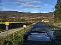
Fish farming at Rohrer Giessen

Concrete pipe at the end of the stream


Web links
Individual evidence
- ↑ a b c Geoserver of the Swiss Federal Administration ( information )
- ^ Website Fischzucht Nadler AG
- ↑ Marcel Käser (inter alia): Beavers renature the Rohrer Schachen