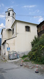
Roncaiola
| Roncaiola | |||
|---|---|---|---|

|
|||
| Roncaiola | |||
| Country | Italy | ||
| region | Lombardy | ||
| province | Sondrio (SO) | ||
| local community | Tirano | ||
| Coordinates | 46 ° 13 ' N , 10 ° 10' E | ||
| height | 802 m slm | ||
| Residents | 40 () | ||
| patron | Santo Stefano | ||
| Telephone code | 0342 | CAP | 23037 |
Roncaiola is a fraction of the municipality of Tirano in the province of Sondrio , Lombardy in Italy and is located on the southern slope of Monte Masuccio at about 802 m above sea level, about 1.5 km as the crow flies from the Swiss border. It is about 3 km to Tirano.
history
Roncaiola was settled in prehistoric times. The Santo Stefano Church was built in 1690. The first natural road was built in 1922, and electrical energy has been available in the village since 1928. In 2017, 40 people lived in the village.
economy
Roncaiola was and is dominated by agriculture, mainly through viticulture . Tourism plays a subordinate role.
Due to the lack of employment opportunities in Roncaiola, the separation of the Valtellina from Switzerland in 1798 and the proximity to the now Swiss border, a brisk smuggling activity developed in the 19th century, which ensured a certain prosperity in the village. When the lira was devalued in the 1970s , the profit margins in traditional smuggling from Switzerland to Italy also fell sharply and smuggling activity also fell drastically.
traffic
Roncaiola is located on an old traffic route from San Romerio (Berninaroute - Via Bernina ) to Switzerland and the Lake Constance area ( Via Valtellina ) over the Bernina Pass and the northern Italian plain ( Po Valley ) to Italy.
Attractions
Hiking trails
Roncaiola is the starting point or destination of several hiking trails or is affected by them. The bread path and the path of smuggling and memory as well as the hiking path to and from Tirano are known. There is also the possibility of using various trails for mountain bikers .
Bread path
The bread path ( Italian : Sentiero del pane) leads from Roncaiola about 4 km to Baruffini and recalls the path that the inhabitants of the village of Roncaiola had to take to have the grain ( rye ) ground for bread in Baruffini . The trail was opened on May 26, 2007, starts very steeply in Roncaiola and then drops down to Baruffini. It leads between old, formerly agricultural terraces largely in the shade of maple trees , chestnuts and birches . Several Crotti can be found in a well-preserved condition along the way.
Path of smuggling and memory
Above Roncaiola runs the "Trail of Smuggling and Remembrance" ( Italian : Sentiero del contrabbande), which was opened in 2007 and leads to and from Baruffini. The trail is dedicated to two victims of smuggling in the last century, Irma Rinaldi (smuggler) and Dario Cinus (financial guard). The length of the circular route is around 8.5 km, the difference in altitude around 450 meters and the hiking time around 4 hours. At the church of Santo Stefano there is another plaque commemorating the border guard Antonio Farci.
Hiking trail to Tirano
From or to Roncaiola a very interesting hiking trail leads to Tirano through vineyards and former, agricultural terraces and forest, where old shelters, storage rooms and irrigation systems can be found and past the old cemetery of Roncaiola. The hiking time is around 1.25 hours and the difference in altitude is around 380 meters.
Web links
Individual evidence
- ^ Comune di Tirano - Statuto .
- ↑ Village of Roncaiola
- ↑ S. Massera: Paesi e paesani di Valtellina nella descrizione di un anonimo del Seicento , in “Valtellina e Valchiavenna - rassegna economica della provincia di Sondrio” n. 4, 1976.
- ↑ Smuggling epic between Valtellina and Poschiavo , website: swissinfo.ch.


