Rose (Jeetzbach)
| rose | ||
|
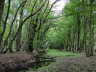
Rose in the Perleberg city forest |
||
| Data | ||
| Water code | DE : 591488 | |
| location | Germany , Perleberg | |
| River system | Elbe | |
| Drain over | Jeetzbach → Stepenitz → Elbe → North Sea | |
| source | at Rosenhagen 53 ° 4 '50 " N , 11 ° 54' 58" E |
|
| muzzle | South of Perleberg Coordinates: 53 ° 2 '25 " N , 11 ° 51' 30" E 53 ° 2 '25 " N , 11 ° 51' 30" E
|
|
| length | approx. 7.7 km | |
The Rose is an approximately 8.5 kilometers long, right tributary of the Jeetzbach . It extends to the east and south of the city of Perleberg in the Brandenburg district of Prignitz .
course
The stream rises in the Perleberg district of Rosenhagen . It is fed from the ditches of the street village. Further ditches in the agricultural area increase its water volume shortly afterwards.
The Rose initially flows canalised with a few bends in a south-westerly direction parallel to the Groß Pankow – Perleberg railway line . Then it is the only street in its course that crosses federal highway 5 between Perleberg and the district of Düpow .
The creek of the Perleberger Landwehr follows . Now no longer canalised, the rose enters the Perleberg city forest and roughly forms the border between Vorderheide in the north-west and Düpower Heide in the south-east. Here the rose flows in two parts in the beds of the Landwehr trenches. The walls of the historical fortifications can still be seen.
On their last piece of the Rose winds strongly before settling near the old Torstandort Boll bridge at the Wilsnacker pours Chaussee in Jeetzbach.
swell
- Dieter Hoffmann-Axthelm: Perleberg in the Middle Ages - urban development and history . Lukas Verlag, Berlin 2010. ISBN 978-3-86732-083-2 . P. 71 ff., The Landwehr .
Individual evidence
- ↑ River directory gewnet25 (Version 4.0, April 24, 2014) from the Ministry for Rural Development, Environment and Agriculture of the State of Brandenburg, accessed on May 4, 2015.
