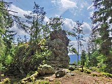
Rotenfels (Fichtel Mountains)
The Rotenfels (745 m above sea level) is a ten meter high rock face in the Flötzwald north of Ahornberg , a district of the municipality of Immenreuth ( Tirschenreuth district ) in the Fichtel Mountains (northeast Bavaria). Iron ore ( hematite ) gave rise to the reddish discoloration of the rock and the name of the mountain and field.
Flötzwald
The Flötzwald is a densely forested area in the south-western Fichtelgebirge with partly heavily indented stream valleys. With a size of about 300 hectares, the forest area has belonged to the city of Kemnath since 1559 . Its name originated from the rafting of logs for the city of Kemnath.
Mining
There is documentary evidence that iron ore has been mined at Rotenfels since 1507, and that it was sent to the surrounding melting furnaces and hammer mills for further processing. Mining activities continued into the 18th century.
literature
- Dietmar Herrmann, Helmut Süssmann: Fichtel Mountains, Bavarian Vogtland, Steinwald, Bayreuther Land. Lexicon . Ackermannverlag, Hof (Saale) 2000, ISBN 3-929364-18-2 .
- Dirk Götschmann : Upper Palatinate Iron, United Upper Palatinate Printing Works u. Verl.-Anst., Weiden / Amberg, 1986, Volume 5 of the series of publications by the Mining and Industry Museum in East Bavaria in Theuern (see location register), ISBN 3-924350-05-1
- Elisabeth Jäger : Wunsiedel 1163–1560, Volume I, 1987, p. 81,
- Mathias Flurl : Description of the mountains of Baiern and the upper Palatinate, 1792, p. 479 [1]
- Stefan Meier: The Flötztal in the southern Fichtelgebirge, Lapis , vol. 32, no. 1/2007, pp. 17-20
- Dietmar Herrmann: The Rotenfels in the Flötzwaldung near Kemnath ; in: Der Siebenstern 2014, pp. 175–177
Web links
http://www.bayern-fichtelgebirge.de/heimatkunde/DerRotenfels.pdf
Maps
- Fritsch hiking map of the Fichtelgebirge and Steinwald Nature Park, No. 52, scale 1: 50,000
- Bavaria Atlas
Individual evidence
Coordinates: 49 ° 56 ′ 56.4 " N , 11 ° 49 ′ 40.8" E
