Red Buhl
|
Red Buhl
City of Nuremberg
Coordinates: 49 ° 21 ′ 27 ″ N , 11 ° 4 ′ 21 ″ E
|
|
|---|---|
| Height : | 340–341 m above sea level NN |
| Postal code : | 90455 |
| Area code : | 0911 |
|
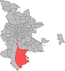
Location of the statistical district 49
|
|
Roter Bühl is the name of a hamlet in the south of Nuremberg . The settlement is named after the neighboring forest of Roter Bühl to the east , has the zip code 90455 and belongs to the statistical district 49. The development began in the 1950s.
location
Roter Bühl is located in the south of the city of Nuremberg at an altitude of 341 m above sea level. NN and is completely within the Worzeldorf district . Spatially closer, however, are the district Katzwang 1 km west and Gaulnhofen 1 km north . All streets in the settlement are called Am Roten Bühl. The Main-Danube Canal runs 600 meters to the west ; a bridge leads there to Neukatzwang .
The settlement is in a cul-de-sac that branches off to the east of the N1 district road, which is called Kemptener Strasse there . At the junction, 300 meters from the residential area, there is a VGN stop on demand, which uses line 52 every 20 minutes on weekdays to Nürnberg- Langwasser and Katzwang. In the evenings as well as on Sundays and public holidays there is a bus only every 40 minutes.

