Rumdoodle Peak
| Rumdoodle Peak | ||
|---|---|---|
|
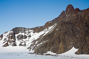
Rumdoodle Peak with a green refuge |
||
| height | 875 m | |
| location | Mac Robertson Land , East Antarctica | |
| Mountains | North Masson Range in the Framnes Mountains | |
| Coordinates | 67 ° 46 '17 " S , 62 ° 49' 49" O | |
|
|
||
|
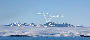
The North Masson Range viewed from the sea with Mawson Station visible in the foreground |
||
The Rumdoodle Peak is a 875 m high and prominent mountain in the East Antarctic Mac Robertson Land . It rises in the northwest section of the North Masson Range in the Framnes Mountains southwest of the Painted Peak . At a height of 498 m there is a small shelter for five people. There are also two permanently frozen lakes, Rumdoodle Lake and Lassitude Lake .
Norwegian cartographers mapped it in 1946 using aerial photographs of the Lars Christensen Expedition in 1936/37 . The Antarctic Names Committee of Australia named it in 1964 after the novel The Ascent of Rum Doodle by British writer William Ernest Bowman from 1956, which is one of the most widely read works on the neighboring Mawson station .
Web links
- Rumdoodle Peak in the Composite Gazetteer of Antarctica (English)


