Russellville, Alabama
| Russellville | |
|---|---|
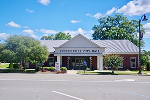
 City Hall (2018) |
|
| Location of Russellville, County and Alabama | |
| Basic data | |
| Foundation : | 1819 |
| State : | United States |
| State : | Alabama |
| County : | Franklin County |
| Coordinates : | 34 ° 31 ′ N , 87 ° 44 ′ W |
| Time zone : | Central ( UTC − 6 / −5 ) |
| Residents : | 8,971 (as of: 2000) |
| Population density : | 261.5 inhabitants per km 2 |
| Area : | 34.6 km 2 (approx. 13 mi 2 ) of which 34.3 km 2 (approx. 13 mi 2 ) are land |
| Height : | 233 m |
| Postcodes : | 35653-35654 |
| Area code : | +1 256 |
| FIPS : | 01-67056 |
| GNIS ID : | 0126047 |
| Website : | www.russellvilleal.org |
Russellville is a city in Franklin County , Alabama in the United States . The city was named after the settler William Russell. The place is the county seat of Franklin County. Russellville had around 8971 inhabitants in the 2000 United States Census .
Two structures and sites in Russelville and the surrounding area are listed on the National Register of Historic Places (NRHP) as of March 19, 2020, the Alabama Iron Works and the Russellville Commercial Historic District .
Web links
Individual evidence
-
↑ Search mask database in the National Register Information System. National Park Service , accessed March 19, 2020.
Weekly List on the National Register Information System. National Park Service , accessed March 19, 2020.
