Sao Gabriel (Rio Grande do Sul)
| Sao Gabriel | ||
|---|---|---|
|
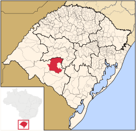
Coordinates: 30 ° 20 ′ S , 54 ° 19 ′ W Sao Gabriel on the map of Rio Grande do Sul
|
||
| Basic data | ||
| Country | Brazil | |
| State | Rio Grande do Sul | |
| City foundation | April 4, 1800 | |
| Residents | 60,425 (IBGE / 2010) | |
| City insignia | ||
| Detailed data | ||
| surface | 5,019.646 km 2 | |
| Population density | 12.03 inhabitants / km 2 | |
| height | 114 m | |
| Time zone | UTC −3 | |
| Website | ||
| Location of São Gabriel in Rio Grande do Sul | ||
São Gabriel is a historically significant city with 62,061 inhabitants (as of 2018) in the state of Rio Grande do Sul in southern Brazil .
geography
The city is about 320 km west of Porto Alegre . Neighboring are the places Rosário do Sul , Santa Margarida do Sul , Vila Nova do Sul , Cacequi , Lavras do Sul , Dilermando de Aguiar , Dom Pedrito , São Sepé and Santa Maria .
sons and daughters of the town
- Gastão Paranhos do Rio Branco (1888–1961), diplomat
Web links
- IBGE to São Gabriel in Rio Grande do Sul. Retrieved July 13, 2019 (Brazilian Portuguese).


